|
|
|
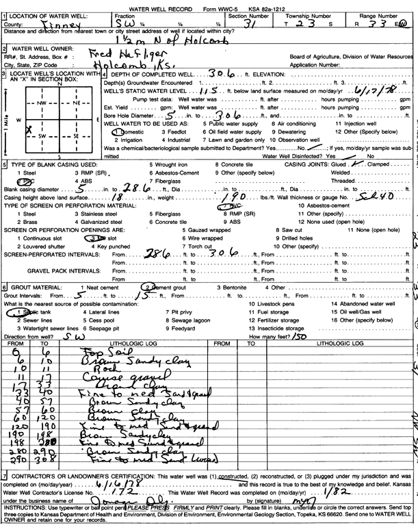
Specific Water Well Detail |
|
|
| Location Info | |||
| Owner: Hafliger, Fred | Status: Constructed | ||
| Location: T23S, R33W, Sec. 31, SW | County: Finney | ||
| Directions: from Holcomb, 1.5 mi N | |||
| Latitude: 38.0072062 | Longitude: -100.9884131 | Datum NAD 27 | |
| Latitude: 38.0072304 | Longitude: -100.9888569 | Datum NAD 83 | |
| Longitude and latitude calculated by Survey from township-range-section-quarter calls. Only good to within the quarter call accuracy. | |||
| View well on interactive map | |||
| General Info | ||
| Well Depth: 306 ft. | Elevation: ft. | |
| Static Water Level: 115 ft. | Est. Yield: gpm. | |
| Comp. Date: 16-Jun-1978 | Well Use: Domestic | |
| DWR Applic. #: | Other ID: | |
| Driller Info | ||
| Driller: Jonagan Water Well Service LLC | License #: 172 | |
| Scanned Form | View scan |
|
Chemical Sample Submitted?: No
Water Well disinfected?: | ||
| Ground water encountered: 0 ft. , 0 ft. , 0 ft. | ||
| Pump test data: Well water was 0 ft after 0 hours pumping 0 gpm | ||
| Casing Info | ||
| Casing Type:
Casing Joints: |
Diam: 0 in. to 0 ft
Diam: 0 in. to 0 ft Diam: 0 in. to 0 ft | |
| Casing height above land surface: in
Casing Weight: lbs/ft Wall thickness or gauge no.: | ||
| Screen and Perforation Info | ||
| Screen Type: | Screen Openings: | |
| Screen-perforated intervals | From: 286 ft to 306 ft
From: 0 ft to 0 ft From: 0 ft to 0 ft | |
| Gravel pack intervals | From: ft to ft | |
| Grout Info | ||
| Grout used: | From: 0 to 0 ft
From: 0 to 0 ft From: 0 to 0 ft | |
| Source of Possible Contamination | ||
| Source: | ||
| Direction from well: | Distance: 0 ft | |
| Lithologic Log
(Log data entered by KGS.) | ||
| From: 0 ft. to 6 ft. | top soil | |
| From: 6 ft. to 10 ft. | brown sandy clay | |
| From: 10 ft. to 11 ft. | rock | |
| From: 11 ft. to 17 ft. | coarse gravel | |
| From: 17 ft. to 33 ft. | brown clay | |
| From: 33 ft. to 40 ft. | fine to medium sand and gravel | |
| From: 40 ft. to 57 ft. | brown sandy clay | |
| From: 57 ft. to 60 ft. | brown clay | |
| From: 60 ft. to 120 ft. | brown sandy clay | |
| From: 120 ft. to 190 ft. | fine to medium sand and gravel | |
| From: 190 ft. to 198 ft. | brown sandy clay | |
| From: 198 ft. to 280 ft. | fine to medium sand and gravel | |
| From: 280 ft. to 290 ft. | brown sandy clay | |
| From: 290 ft. to 308 ft. | fine to medium sand (loose) | |