|
|
|
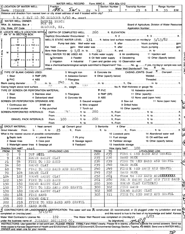
Specific Water Well Detail |
|
|
| Location Info | |||
| Owner: Reece, Dennis | Status: Constructed | ||
| Location: T23S, R33W, Sec. 31, NE SW SW | County: Finney | ||
| Directions: from Holcomb, 1 mi N on Hwy 50 and 0.4 mi E | |||
| Latitude: 38.0062981 | Longitude: -100.9895402 | Datum NAD 27 | |
| Latitude: 38.0063223 | Longitude: -100.9899841 | Datum NAD 83 | |
| Longitude and latitude calculated by Survey from township-range-section-quarter calls. Only good to within the quarter call accuracy. | |||
| View well on interactive map | |||
| General Info | ||
| Well Depth: 260 ft. | Elevation: ft. | |
| Static Water Level: 131 ft. | Est. Yield: gpm. | |
| Comp. Date: 13-May-1982 | Well Use: Domestic | |
| DWR Applic. #: | Other ID: | |
| Driller Info | ||
| Driller: Jonagan Water Well Service LLC | License #: 172 | |
| Scanned Form | View scan |
|
Chemical Sample Submitted?: No
Water Well disinfected?: | ||
| Ground water encountered: 0 ft. , 0 ft. , 0 ft. | ||
| Pump test data: Well water was 0 ft after 0 hours pumping 0 gpm | ||
| Casing Info | ||
| Casing Type:
Casing Joints: |
Diam: 0 in. to 0 ft
Diam: 0 in. to 0 ft Diam: 0 in. to 0 ft | |
| Casing height above land surface: in
Casing Weight: lbs/ft Wall thickness or gauge no.: | ||
| Screen and Perforation Info | ||
| Screen Type: | Screen Openings: | |
| Screen-perforated intervals | From: 240 ft to 260 ft
From: 0 ft to 0 ft From: 0 ft to 0 ft | |
| Gravel pack intervals | From: ft to ft | |
| Grout Info | ||
| Grout used: | From: 0 to 0 ft
From: 0 to 0 ft From: 0 to 0 ft | |
| Source of Possible Contamination | ||
| Source: | ||
| Direction from well: | Distance: 0 ft | |
| Lithologic Log
(Log data entered by KGS.) | ||
| From: 0 ft. to 9 ft. | top soil | |
| From: 9 ft. to 21 ft. | brown sandy clay | |
| From: 21 ft. to 54 ft. | fine to medium sand | |
| From: 54 ft. to 60 ft. | brown clay | |
| From: 60 ft. to 70 ft. | fine to medium sand and gravel | |
| From: 70 ft. to 104 ft. | brown clay | |
| From: 104 ft. to 122 ft. | brown sandy clay | |
| From: 122 ft. to 130 ft. | fine to medium sand | |
| From: 130 ft. to 150 ft. | brown sandy clay | |
| From: 150 ft. to 170 ft. | fine to medium sand and gravel | |
| From: 170 ft. to 180 ft. | brown sandy clay | |
| From: 180 ft. to 186 ft. | fine sand | |
| From: 186 ft. to 202 ft. | brown clay | |
| From: 202 ft. to 219 ft. | fine to medium sand and gravel | |
| From: 219 ft. to 220 ft. | hard rock | |
| From: 220 ft. to 235 ft. | fine to medium sand and gravel | |
| From: 235 ft. to 236 ft. | hard rock | |
| From: 236 ft. to 239 ft. | fine to medium sand and gravel | |
| From: 239 ft. to 240 ft. | hard rock | |
| From: 240 ft. to 249 ft. | fine to medium sand and gravel | |
| From: 249 ft. to 252 ft. | hard rock | |
| From: 252 ft. to 261 ft. | fine to medium sand | |
| From: 261 ft. to 280 ft. | brown sandy clay and fine sand | |
| From: 280 ft. to 300 ft. | brown clay (sticky) | |
| From: 300 ft. to 302 ft. | fine sand | |
| From: 302 ft. to 308 ft. | brown sandy clay | |
| From: 308 ft. to 311 ft. | fine to medium sand and gravel | |