|
|
|
Specific Water Well Detail |
|
|
| Location Info | |||
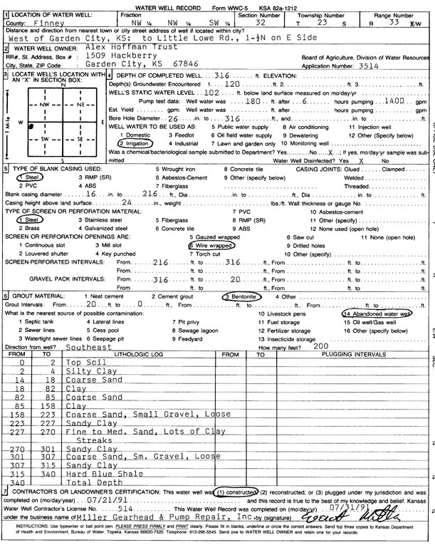
| Owner: Alex Hoffman Trust | Status: Constructed | ||
| Location: T23S, R33W, Sec. 32, NW NW SW | County: Finney | ||
| Directions: W of Garden City: to Little Lowe Rd, 1.5 N, on E side | |||
| Latitude: 38.0099195 | Longitude: -100.9738199 | Datum NAD 27 | |
| Latitude: 38.0099436 | Longitude: -100.9742631 | Datum NAD 83 | |
| Longitude and latitude calculated by Survey from township-range-section-quarter calls. Only good to within the quarter call accuracy. | |||
| View well on interactive map | |||
| General Info | ||
| Well Depth: 316 ft. | Elevation: ft. | |
| Static Water Level: 102 ft. | Est. Yield: gpm. | |
| Comp. Date: 21-Jul-1991 | Well Use: Irrigation | |
| DWR Applic. #: 3514 | Other ID: | |
| Links | |
| No Wizard information available. | |
| View info from WIMAS Water Right Data base... | |
| Driller Info | ||
| Driller: Everett Miller Gearhead & Pump Repair | License #: 514 | |
| Scanned Form | View scan |
|
Chemical Sample Submitted?: No
Water Well disinfected?: | ||
| Ground water encountered: 120 ft. , 0 ft. , 0 ft. | ||
| Pump test data: Well water was 180 ft after 6 hours pumping 1400 gpm | ||
| Casing Info | ||
| Casing Type: Steel
Casing Joints: |
Diam: 16 in. to 216 ft
Diam: 0 in. to 0 ft Diam: 0 in. to 0 ft | |
| Casing height above land surface: in
Casing Weight: lbs/ft Wall thickness or gauge no.: | ||
| Screen and Perforation Info | ||
| Screen Type: Steel | Screen Openings: Wire wrapped | |
| Screen-perforated intervals | From: 216 ft to 316 ft
From: 0 ft to 0 ft From: 0 ft to 0 ft | |
| Gravel pack intervals | From: ft to ft | |
| Grout Info | ||
| Grout used: Bentonite | From: 0 to 20 ft
From: 0 to 0 ft From: 0 to 0 ft | |
| Source of Possible Contamination | ||
| Source: Abandoned water well | ||
| Direction from well: | Distance: 0 ft | |
| Lithologic Log
(Log data entered by KGS.) | ||
| From: 0 ft. to 2 ft. | top soil | |
| From: 2 ft. to 4 ft. | silty clay | |
| From: 4 ft. to 18 ft. | coarse sand | |
| From: 18 ft. to 82 ft. | clay | |
| From: 82 ft. to 85 ft. | coarse sand | |
| From: 85 ft. to 158 ft. | clay | |
| From: 158 ft. to 223 ft. | coarse sand, small gravel, loose | |
| From: 223 ft. to 227 ft. | sandy clay | |
| From: 227 ft. to 270 ft. | fine to medium sand, lots of clay streaks | |
| From: 270 ft. to 301 ft. | sandy clay | |
| From: 301 ft. to 307 ft. | coarse sand, sm. gravel, loose | |
| From: 307 ft. to 315 ft. | sandy clay | |
| From: 318 ft. to 340 ft. | hard blue shale | |