|
|
|
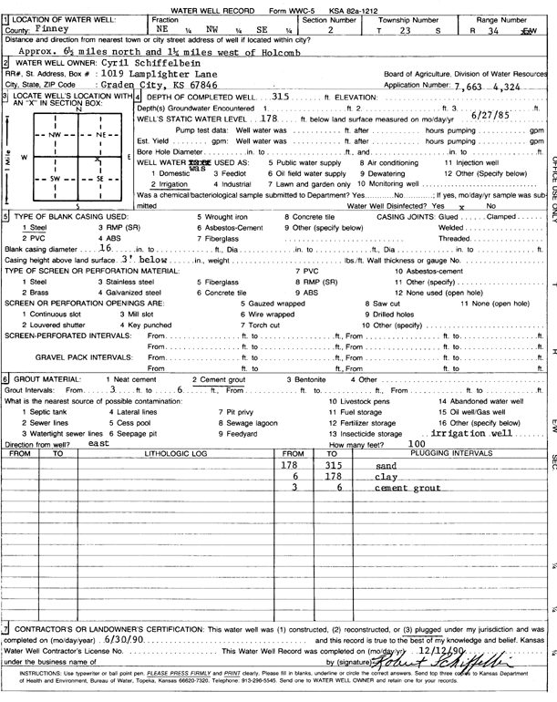
Specific Water Well Detail |
|
|
| Location Info | |||
| Owner: Schiffelbein, Cyril | Status: Plugged | ||
| Location: T23S, R34W, Sec. 2, NE NW SE | County: Finney | ||
| Directions: 6.5 N, 1.25 W of Holcomb | |||
| Latitude: 38.082485 | Longitude: -101.0163048 | Datum NAD 27 | |
| Latitude: 38.0825087 | Longitude: -101.0167472 | Datum NAD 83 | |
| Longitude and latitude calculated by Survey from township-range-section-quarter calls. Only good to within the quarter call accuracy. | |||
| View well on interactive map | |||
| General Info | ||
| Well Depth: 315 ft. | Elevation: ft. | |
| Static Water Level: 178 ft. | Est. Yield: gpm. | |
| Comp. Date: 30-Jun-1990 | Well Use: Irrigation | |
| DWR Applic. #: 7663 | Other ID: | |
| Links | |
| View info from Wizard Water Level Data base... | |
| View info from WIMAS Water Right Data base... | |
| Driller Info | ||
| Driller: Robert Schiffelbein | License #: | |
| Scanned Form | View scan |
| Casing Info | ||
|
Casing Type: Steel
Diam: 16 in. Casing height above land surface: in | ||
| Grout Info | ||
| Grout used: Cement grout | From: 3 to 6 ft
From: 0 to 0 ft From: 0 to 0 ft | |
| Source of Possible Contamination | ||
| Source: OTHER | ||
| Direction from well: | Distance: 0 ft | |