|
|
|
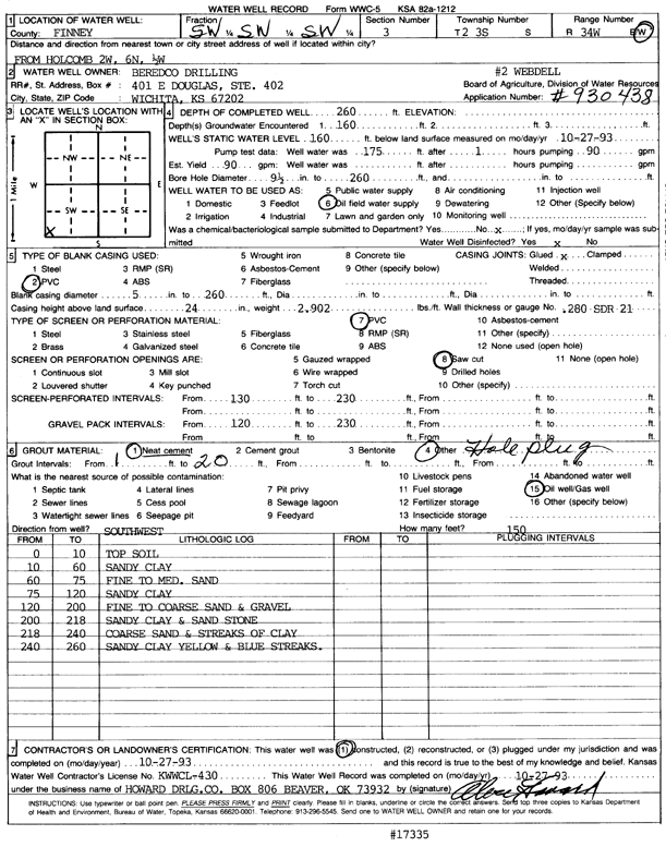
Specific Water Well Detail |
|
|
| Location Info | |||
| Owner: Beredco Drilling | Status: Constructed | ||
| Location: T23S, R34W, Sec. 3, SW SW SW | County: Finney | ||
| Directions: 2 W, 6 N, .5 W from Holcomb | |||
| Latitude: 38.0769194 | Longitude: -101.0462637 | Datum NAD 27 | |
| Latitude: 38.0769428 | Longitude: -101.0467066 | Datum NAD 83 | |
| Longitude and latitude calculated by Survey from township-range-section-quarter calls. Only good to within the quarter call accuracy. | |||
| View well on interactive map | |||
| General Info | ||
| Well Depth: 260 ft. | Elevation: ft. | |
| Static Water Level: 160 ft. | Est. Yield: 90 gpm. | |
| Comp. Date: 27-Oct-1993 | Well Use: Oil Field Water Supply | |
| DWR Applic. #: 930438 | Other ID: Webdell 2 | |
| Links | |
| No Wizard information available. | |
| View info from WIMAS Water Right Data base... | |
| Driller Info | ||
| Driller: Howard Drilling Co. | License #: 430 | |
| Scanned Form | View scan |
|
Chemical Sample Submitted?: No
Water Well disinfected?: | ||
| Ground water encountered: 160 ft. , 0 ft. , 0 ft. | ||
| Pump test data: Well water was 175 ft after 1 hours pumping 90 gpm | ||
| Casing Info | ||
| Casing Type: PVC
Casing Joints: |
Diam: 5 in. to 260 ft
Diam: 0 in. to 0 ft Diam: 0 in. to 0 ft | |
| Casing height above land surface: in
Casing Weight: lbs/ft Wall thickness or gauge no.: | ||
| Screen and Perforation Info | ||
| Screen Type: PVC | Screen Openings: Saw cut | |
| Screen-perforated intervals | From: 130 ft to 230 ft
From: 0 ft to 0 ft From: 0 ft to 0 ft | |
| Gravel pack intervals | From: ft to ft | |
| Grout Info | ||
| Grout used: Neat cement, | From: 1 to 20 ft
From: 0 to 0 ft From: 0 to 0 ft | |
| Source of Possible Contamination | ||
| Source: Oil well/gas well | ||
| Direction from well: | Distance: 0 ft | |
| Lithologic Log
(Log data entered by KGS.) | ||
| From: 0 ft. to 10 ft. | top soil | |
| From: 10 ft. to 60 ft. | sandy clay | |
| From: 60 ft. to 75 ft. | fine to medium sand | |
| From: 75 ft. to 120 ft. | sandy clay | |
| From: 120 ft. to 200 ft. | fine to coarse sand and gravel | |
| From: 200 ft. to 218 ft. | sandy clay and sandstone | |
| From: 218 ft. to 240 ft. | coarse sand and streaks of clay | |
| From: 240 ft. to 260 ft. | sandy clay yellow and blue streaks | |