|
|
|
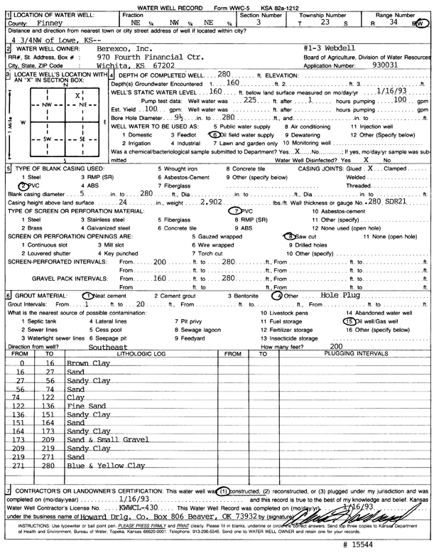
Specific Water Well Detail |
|
|
| Location Info | |||
| Owner: Berexco, Inc. | Status: Constructed | ||
| Location: T23S, R34W, Sec. 3, NE NW NE | County: Finney | ||
| Directions: 4.75 NW of Lowe | |||
| Latitude: 38.0896945 | Longitude: -101.0346775 | Datum NAD 27 | |
| Latitude: 38.0897179 | Longitude: -101.0351199 | Datum NAD 83 | |
| Longitude and latitude calculated by Survey from township-range-section-quarter calls. Only good to within the quarter call accuracy. | |||
| View well on interactive map | |||
| General Info | ||
| Well Depth: 280 ft. | Elevation: ft. | |
| Static Water Level: 160 ft. | Est. Yield: 100 gpm. | |
| Comp. Date: 16-Jan-1993 | Well Use: Oil Field Water Supply | |
| DWR Applic. #: 930031 | Other ID: Webdell 1-3 | |
| Links | |
| No Wizard information available. | |
| View info from WIMAS Water Right Data base... | |
| Driller Info | ||
| Driller: Howard Drilling Co. | License #: 430 | |
| Scanned Form | View scan |
|
Chemical Sample Submitted?: Yes
Water Well disinfected?: | ||
| Ground water encountered: 160 ft. , 0 ft. , 0 ft. | ||
| Pump test data: Well water was 225 ft after 1 hours pumping 100 gpm | ||
| Casing Info | ||
| Casing Type: PVC
Casing Joints: |
Diam: 5 in. to 280 ft
Diam: 0 in. to 0 ft Diam: 0 in. to 0 ft | |
| Casing height above land surface: in
Casing Weight: lbs/ft Wall thickness or gauge no.: | ||
| Screen and Perforation Info | ||
| Screen Type: PVC | Screen Openings: Saw cut | |
| Screen-perforated intervals | From: 200 ft to 280 ft
From: 0 ft to 0 ft From: 0 ft to 0 ft | |
| Gravel pack intervals | From: ft to ft | |
| Grout Info | ||
| Grout used: Neat cement, | From: 1 to 20 ft
From: 0 to 0 ft From: 0 to 0 ft | |
| Source of Possible Contamination | ||
| Source: Oil well/gas well | ||
| Direction from well: | Distance: 0 ft | |
| Lithologic Log
(Log data entered by KGS.) | ||
| From: 0 ft. to 16 ft. | brown clay | |
| From: 16 ft. to 27 ft. | sand | |
| From: 27 ft. to 56 ft. | sandy clay | |
| From: 56 ft. to 74 ft. | sand | |
| From: 74 ft. to 122 ft. | clay | |
| From: 122 ft. to 136 ft. | fine sand | |
| From: 136 ft. to 151 ft. | sandy clay | |
| From: 151 ft. to 164 ft. | sand | |
| From: 164 ft. to 173 ft. | sandy clay | |
| From: 173 ft. to 209 ft. | sand and small gravel | |
| From: 209 ft. to 219 ft. | sandy clay | |
| From: 219 ft. to 271 ft. | sand | |
| From: 271 ft. to 280 ft. | blue and yellow clay | |