|
|
|
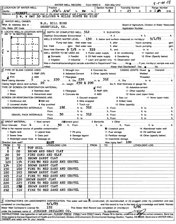
Specific Water Well Detail |
|
|
| Location Info | |||
| Owner: N.S. Bill Bird | Status: Constructed | ||
| Location: T23S, R34W, Sec. 8, NW NW NW | County: Finney | ||
| Directions: from Holcomb, 5 mi W on Hwy 50, 4 mi N, NE side | |||
| Latitude: 38.0749198 | Longitude: -101.082862 | Datum NAD 27 | |
| Latitude: 38.0749426 | Longitude: -101.0833053 | Datum NAD 83 | |
| Longitude and latitude calculated by Survey from township-range-section-quarter calls. Only good to within the quarter call accuracy. | |||
| View well on interactive map | |||
| General Info | ||
| Well Depth: 312 ft. | Elevation: ft. | |
| Static Water Level: 130 ft. | Est. Yield: gpm. | |
| Comp. Date: 01-Sep-1985 | Well Use: Domestic | |
| DWR Applic. #: | Other ID: | |
| Driller Info | ||
| Driller: Jonagan Water Well Service | License #: 172 | |
| Scanned Form | View scan |
|
Chemical Sample Submitted?: No
Water Well disinfected?: | ||
| Ground water encountered: 0 ft. , 0 ft. , 0 ft. | ||
| Pump test data: Well water was 0 ft after 0 hours pumping 0 gpm | ||
| Casing Info | ||
| Casing Type: PVC
Casing Joints: |
Diam: 5 in. to 192 ft
Diam: 0 in. to 0 ft Diam: 0 in. to 0 ft | |
| Casing height above land surface: in
Casing Weight: lbs/ft Wall thickness or gauge no.: | ||
| Screen and Perforation Info | ||
| Screen Type: PVC | Screen Openings: Mill slot | |
| Screen-perforated intervals | From: 192 ft to 312 ft
From: 0 ft to 0 ft From: 0 ft to 0 ft | |
| Gravel pack intervals | From: ft to ft | |
| Grout Info | ||
| Grout used: Cement grout | From: 4 to 30 ft
From: 0 to 0 ft From: 0 to 0 ft | |
| Source of Possible Contamination | ||
| Source: | ||
| Direction from well: | Distance: 0 ft | |
| Lithologic Log
(Log data entered by KGS.) | ||
| From: 0 ft. to 8 ft. | top soil | |
| From: 8 ft. to 20 ft. | brown and gray clay | |
| From: 20 ft. to 30 ft. | fine sand and clay | |
| From: 30 ft. to 120 ft. | brown sandy clay | |
| From: 120 ft. to 134 ft. | fine to medium sand and gravel | |
| From: 134 ft. to 150 ft. | brown sandy clay | |
| From: 150 ft. to 160 ft. | fine to medium sand and gravel | |
| From: 160 ft. to 165 ft. | brown sandy clay | |
| From: 165 ft. to 212 ft. | fine to medium sand and gravel | |
| From: 212 ft. to 220 ft. | brown sandy clay | |
| From: 220 ft. to 225 ft. | fine to medium sand and gravel | |
| From: 225 ft. to 292 ft. | brown sandy clay | |
| From: 292 ft. to 310 ft. | fine to medium sand and gravel | |