|
|
|
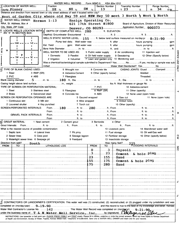
Specific Water Well Detail |
|
|
| Location Info | |||
| Owner: Ensign Operating Co. | Status: Plugged | ||
| Location: T23S, R34W, Sec. 13, SE NE SW | County: Finney | ||
| Directions: W of Garden City from jct old and new Hwy 50: 3 mi N, 0.5 mi W, and 0.25 mi N | |||
| Latitude: 38.0516698 | Longitude: -101.0027042 | Datum NAD 27 | |
| Latitude: 38.0516938 | Longitude: -101.0031471 | Datum NAD 83 | |
| Longitude and latitude calculated by Survey from township-range-section-quarter calls. Only good to within the quarter call accuracy. | |||
| View well on interactive map | |||
| General Info | ||
| Well Depth: 280 ft. | Elevation: ft. | |
| Static Water Level: 155 ft. | Est. Yield: gpm. | |
| Comp. Date: 19-Sep-1990 | Well Use: Oil Field Water Supply | |
| DWR Applic. #: 900373 | Other ID: Herman 1-13 | |
| Links | |
| No Wizard information available. | |
| View info from WIMAS Water Right Data base... | |
| Driller Info | ||
| Driller: T & W Water Well Serv., Inc. | License #: 142 | |
| Scanned Form | View scan |
| Casing Info | ||
|
Casing Type: PVC
Diam: 5 in. Casing height above land surface: in | ||
| Grout Info | ||
| Grout used: Neat cement | From: 3 to 23 ft
From: 155 to 175 ft From: 0 to 0 ft | |
| Source of Possible Contamination | ||
| Source: OTHER | ||
| Direction from well: | Distance: 0 ft | |