|
|
|
Specific Water Well Detail |
|
|
| Location Info | |||
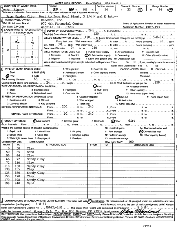
| Owner: Berexco, Inc. | Status: Constructed | ||
| Location: T23S, R34W, Sec. 14, SE NW NW | County: Finney | ||
| Directions: from Garden City: W to Iowa Beef Plant, 3.75 mi N, E into site | |||
| Latitude: 38.0588425 | Longitude: -101.0255119 | Datum NAD 27 | |
| Latitude: 38.0588661 | Longitude: -101.025955 | Datum NAD 83 | |
| Longitude and latitude calculated by Survey from township-range-section-quarter calls. Only good to within the quarter call accuracy. | |||
| View well on interactive map | |||
| General Info | ||
| Well Depth: 240 ft. | Elevation: ft. | |
| Static Water Level: 120 ft. | Est. Yield: 90 gpm. | |
| Comp. Date: 08-May-1987 | Well Use: Oil Field Water Supply | |
| DWR Applic. #: T87-193 | Other ID: | |
| Driller Info | ||
| Driller: Howard Drilling Co. | License #: 430 | |
| Scanned Form | View scan |
|
Chemical Sample Submitted?: No
Water Well disinfected?: | ||
| Ground water encountered: 120 ft. , 0 ft. , 0 ft. | ||
| Pump test data: Well water was 160 ft after 1 hours pumping 90 gpm | ||
| Casing Info | ||
| Casing Type: PVC
Casing Joints: |
Diam: 5 in. to 240 ft
Diam: 0 in. to 0 ft Diam: 0 in. to 0 ft | |
| Casing height above land surface: in
Casing Weight: lbs/ft Wall thickness or gauge no.: | ||
| Screen and Perforation Info | ||
| Screen Type: PVC | Screen Openings: Saw cut | |
| Screen-perforated intervals | From: 200 ft to 240 ft
From: 0 ft to 0 ft From: 0 ft to 0 ft | |
| Gravel pack intervals | From: ft to ft | |
| Grout Info | ||
| Grout used: Neat cement, | From: 1 to 15 ft
From: 0 to 0 ft From: 0 to 0 ft | |
| Source of Possible Contamination | ||
| Source: Oil well/gas well | ||
| Direction from well: | Distance: 0 ft | |
| Lithologic Log
(Log data entered by KGS.) | ||
| From: 0 ft. to 50 ft. | clay | |
| From: 50 ft. to 55 ft. | sand | |
| From: 55 ft. to 66 ft. | clay | |
| From: 66 ft. to 72 ft. | sandy clay | |
| From: 72 ft. to 110 ft. | clay | |
| From: 110 ft. to 130 ft. | sandy clay | |
| From: 130 ft. to 135 ft. | clay | |
| From: 135 ft. to 150 ft. | sandy clay | |
| From: 150 ft. to 170 ft. | clay | |
| From: 170 ft. to 198 ft. | sandy clay | |
| From: 198 ft. to 240 ft. | sand | |