|
|
|
Specific Water Well Detail |
|
|
| Location Info | |||
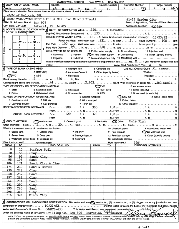
| Owner: Harris Oil and Gas | Status: Constructed | ||
| Location: T23S, R34W, Sec. 19, S2 NE SW | County: Finney | ||
| Directions: from Holcomb, 6.5 mi NW | |||
| Latitude: 38.0366772 | Longitude: -101.0955823 | Datum NAD 27 | |
| Latitude: 38.0366999 | Longitude: -101.0960268 | Datum NAD 83 | |
| Longitude and latitude calculated by Survey from township-range-section-quarter calls. Only good to within the quarter call accuracy. | |||
| View well on interactive map | |||
| General Info | ||
| Well Depth: 320 ft. | Elevation: ft. | |
| Static Water Level: 130 ft. | Est. Yield: 100 gpm. | |
| Comp. Date: 23-Oct-1992 | Well Use: Oil Field Water Supply | |
| DWR Applic. #: 920389 | Other ID: Garden City 1-19 | |
| Driller Info | ||
| Driller: Howard Drilling Co. | License #: 430 | |
| Scanned Form | View scan |
|
Chemical Sample Submitted?: No
Water Well disinfected?: | ||
| Ground water encountered: 130 ft. , 0 ft. , 0 ft. | ||
| Pump test data: Well water was 221 ft after 1 hours pumping 100 gpm | ||
| Casing Info | ||
| Casing Type: PVC
Casing Joints: |
Diam: 5 in. to 320 ft
Diam: 0 in. to 0 ft Diam: 0 in. to 0 ft | |
| Casing height above land surface: in
Casing Weight: lbs/ft Wall thickness or gauge no.: | ||
| Screen and Perforation Info | ||
| Screen Type: PVC | Screen Openings: Saw cut | |
| Screen-perforated intervals | From: 200 ft to 300 ft
From: 0 ft to 0 ft From: 0 ft to 0 ft | |
| Gravel pack intervals | From: ft to ft | |
| Grout Info | ||
| Grout used: Neat cement, | From: 1 to 20 ft
From: 0 to 0 ft From: 0 to 0 ft | |
| Source of Possible Contamination | ||
| Source: Oil well/gas well | ||
| Direction from well: | Distance: 0 ft | |
| Lithologic Log
(Log data entered by KGS.) | ||
| From: 0 ft. to 10 ft. | surface soil | |
| From: 10 ft. to 56 ft. | clay | |
| From: 56 ft. to 95 ft. | sandy clay | |
| From: 95 ft. to 106 ft. | sand | |
| From: 106 ft. to 174 ft. | sandy clay and clay | |
| From: 174 ft. to 230 ft. | sand and gravel | |
| From: 230 ft. to 248 ft. | clay | |
| From: 248 ft. to 257 ft. | sand | |
| From: 257 ft. to 264 ft. | clay | |
| From: 264 ft. to 281 ft. | sand | |
| From: 281 ft. to 290 ft. | clay | |
| From: 290 ft. to 298 ft. | sand | |
| From: 298 ft. to 316 ft. | clay | |
| From: 316 ft. to 320 ft. | black clay | |