|
|
|
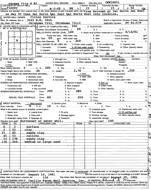
Specific Water Well Detail |
|
|
| Location Info | |||
| Owner: Cities Service | Status: Constructed | ||
| Location: T23S, R34W, Sec. 23, C SE NW | County: Finney | ||
| Directions: from Holcomb: 1 mi N, 2 mi W on HWY 50, 2 mi N, .5 mi E, .5 N, W into site | |||
| Latitude: 38.0415483 | Longitude: -101.0220283 | Datum NAD 27 | |
| Latitude: 38.0415721 | Longitude: -101.0224719 | Datum NAD 83 | |
| Longitude and latitude calculated by Survey from township-range-section-quarter calls. Only good to within the quarter call accuracy. | |||
| View well on interactive map | |||
| General Info | ||
| Well Depth: 260 ft. | Elevation: ft. | |
| Static Water Level: 180 ft. | Est. Yield: 60 gpm. | |
| Comp. Date: 14-Aug-1981 | Well Use: Oil Field Water Supply | |
| DWR Applic. #: PT81-579 | Other ID: Garden City H 2 | |
| Driller Info | ||
| Driller: Bernard E. Carlile Water Well Service, Inc. | License #: 118 | |
| Scanned Form | View scan |
|
Chemical Sample Submitted?: No
Water Well disinfected?: | ||
| Ground water encountered: 0 ft. , 0 ft. , 0 ft. | ||
| Pump test data: Well water was 0 ft after 0 hours pumping 0 gpm | ||
| Casing Info | ||
| Casing Type:
Casing Joints: |
Diam: 0 in. to 0 ft
Diam: 0 in. to 0 ft Diam: 0 in. to 0 ft | |
| Casing height above land surface: in
Casing Weight: lbs/ft Wall thickness or gauge no.: | ||
| Screen and Perforation Info | ||
| Screen Type: | Screen Openings: | |
| Screen-perforated intervals | From: 200 ft to 260 ft
From: 0 ft to 0 ft From: 0 ft to 0 ft | |
| Gravel pack intervals | From: ft to ft | |
| Grout Info | ||
| Grout used: | From: 0 to 0 ft
From: 0 to 0 ft From: 0 to 0 ft | |
| Source of Possible Contamination | ||
| Source: | ||
| Direction from well: | Distance: 0 ft | |
| Lithologic Log
(Log data entered by KGS.) | ||
| From: 0 ft. to 2 ft. | surface | |
| From: 2 ft. to 23 ft. | clay | |
| From: 23 ft. to 45 ft. | sandy clay | |
| From: 45 ft. to 53 ft. | caliche | |
| From: 53 ft. to 178 ft. | sandy clay | |
| From: 178 ft. to 260 ft. | medium to large sand | |