|
|
|
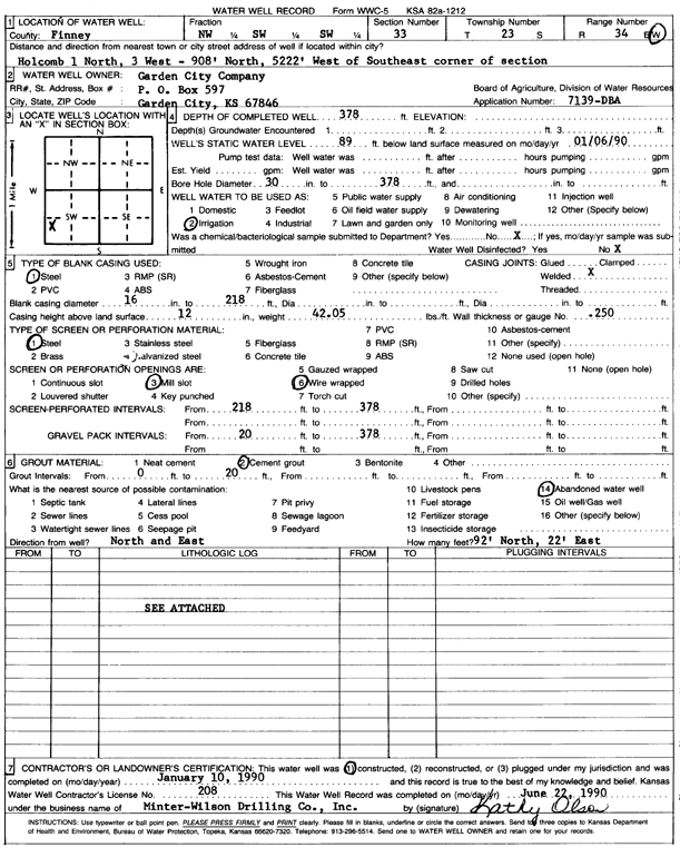
Specific Water Well Detail |
|
|
| Location Info | |||
| Owner: Garden City Co. | Status: Constructed | ||
| Location: T23S, R34W, Sec. 33, NW SW SW | County: Finney | ||
| Directions: Holcomb 1 N, 3 W, 908' N 5222' W of SE corner of section | |||
| Latitude: 38.0060124 | Longitude: -101.0650147 | Datum NAD 27 | |
| Latitude: 38.0060355 | Longitude: -101.0654596 | Datum NAD 83 | |
| Longitude and latitude calculated by Survey from township-range-section-quarter calls. Only good to within the quarter call accuracy. | |||
| View well on interactive map | |||
| General Info | ||
| Well Depth: 378 ft. | Elevation: ft. | |
| Static Water Level: 89 ft. | Est. Yield: gpm. | |
| Comp. Date: 10-Jan-1990 | Well Use: Irrigation | |
| DWR Applic. #: 7139-DBA | Other ID: | |
| Links | |
| No Wizard information available. | |
| View info from WIMAS Water Right Data base... | |
| Driller Info | ||
| Driller: MW Drilling | License #: 208 | |
| Scanned Form | View scan |
|
Chemical Sample Submitted?: No
Water Well disinfected?: | ||
| Ground water encountered: 0 ft. , 0 ft. , 0 ft. | ||
| Pump test data: Well water was 0 ft after 0 hours pumping 0 gpm | ||
| Casing Info | ||
| Casing Type: Steel
Casing Joints: |
Diam: 16 in. to 218 ft
Diam: 0 in. to 0 ft Diam: 0 in. to 0 ft | |
| Casing height above land surface: in
Casing Weight: lbs/ft Wall thickness or gauge no.: | ||
| Screen and Perforation Info | ||
| Screen Type: Steel | Screen Openings: Mill slot | |
| Screen-perforated intervals | From: 218 ft to 378 ft
From: 0 ft to 0 ft From: 0 ft to 0 ft | |
| Gravel pack intervals | From: ft to ft | |
| Grout Info | ||
| Grout used: Cement grout | From: 0 to 20 ft
From: 0 to 0 ft From: 0 to 0 ft | |
| Source of Possible Contamination | ||
| Source: Abandoned water well | ||
| Direction from well: | Distance: 0 ft | |
| Lithologic Log
(log data not edited or checked by the KGS.) | ||
| From: 0 ft. to 2 ft. | Type: CLAY | |
| From: 2 ft. to 108 ft. | Type: SAND & GRAVEL | |
| From: 108 ft. to 159 ft. | Type: SANDY CLAY | |
| From: 159 ft. to 184 ft. | Type: SAND | |
| From: 184 ft. to 196 ft. | Type: SANDY CLAY | |
| From: 196 ft. to 230 ft. | Type: SAND & GRAVEL | |
| From: 230 ft. to 283 ft. | Type: SANDY CLAY | |
| From: 283 ft. to 300 ft. | Type: SAND | |
| From: 300 ft. to 311 ft. | Type: SANDY CLAY | |
| From: 311 ft. to 322 ft. | Type: SAND | |
| From: 322 ft. to 352 ft. | Type: SAND & GRAVEL | |
| From: 352 ft. to 391 ft. | Type: CLAY | |
| From: 391 ft. to 395 ft. | Type: SHALE | |