|
|
|
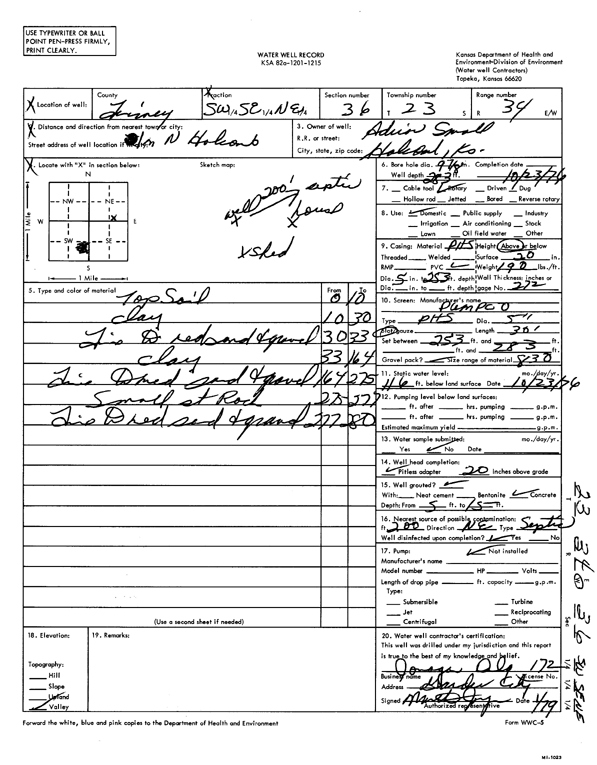
Specific Water Well Detail |
|
|
| Location Info | |||
| Owner: Small, Adrian | Status: Constructed | ||
| Location: T23S, R34W, Sec. 36, SW SE NE | County: Finney | ||
| Directions: from Holcomb, 1 mi N | |||
| Latitude: 38.0117271 | Longitude: -100.9962479 | Datum NAD 27 | |
| Latitude: 38.0117513 | Longitude: -100.9966918 | Datum NAD 83 | |
| Longitude and latitude calculated by Survey from township-range-section-quarter calls. Only good to within the quarter call accuracy. | |||
| View well on interactive map | |||
| General Info | ||
| Well Depth: 283 ft. | Elevation: ft. | |
| Static Water Level: 116 ft. | Est. Yield: gpm. | |
| Comp. Date: 23-Oct-1976 | Well Use: Domestic | |
| DWR Applic. #: | Other ID: | |
| Driller Info | ||
| Driller: Jonagan Water Well Service LLC | License #: 172 | |
| Scanned Form | View scan |
|
Chemical Sample Submitted?: No
Water Well disinfected?: | ||
| Ground water encountered: 0 ft. , 0 ft. , 0 ft. | ||
| Pump test data: Well water was 0 ft after 0 hours pumping 0 gpm | ||
| Casing Info | ||
| Casing Type:
Casing Joints: |
Diam: 0 in. to 0 ft
Diam: 0 in. to 0 ft Diam: 0 in. to 0 ft | |
| Casing height above land surface: in
Casing Weight: lbs/ft Wall thickness or gauge no.: | ||
| Screen and Perforation Info | ||
| Screen Type: | Screen Openings: | |
| Screen-perforated intervals | From: 253 ft to 283 ft
From: 0 ft to 0 ft From: 0 ft to 0 ft | |
| Gravel pack intervals | From: ft to ft | |
| Grout Info | ||
| Grout used: | From: 0 to 0 ft
From: 0 to 0 ft From: 0 to 0 ft | |
| Source of Possible Contamination | ||
| Source: | ||
| Direction from well: | Distance: 0 ft | |
| Lithologic Log
(Log data entered by KGS.) | ||
| From: 0 ft. to 10 ft. | top soil | |
| From: 10 ft. to 30 ft. | clay | |
| From: 30 ft. to 33 ft. | fine to medium sand and gravel | |
| From: 33 ft. to 164 ft. | clay | |
| From: 164 ft. to 275 ft. | fine to medium sand and gravel | |
| From: 275 ft. to 277 ft. | small st rock | |
| From: 277 ft. to 280 ft. | fine to medium sand and gravel | |