|
|
|
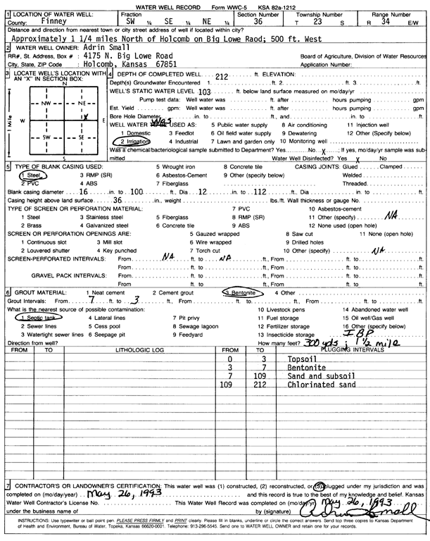
Specific Water Well Detail |
|
|
| Location Info | |||
| Owner: Small, Adrian | Status: Plugged | ||
| Location: T23S, R34W, Sec. 36, SW SE NE | County: Finney | ||
| Directions: from Holcomb, 1.25 mi N on Big Lowe Rd, 500 feet W | |||
| Latitude: 38.0117271 | Longitude: -100.9962479 | Datum NAD 27 | |
| Latitude: 38.0117513 | Longitude: -100.9966918 | Datum NAD 83 | |
| Longitude and latitude calculated by Survey from township-range-section-quarter calls. Only good to within the quarter call accuracy. | |||
| View well on interactive map | |||
| General Info | ||
| Well Depth: 212 ft. | Elevation: ft. | |
| Static Water Level: 103 ft. | Est. Yield: gpm. | |
| Comp. Date: 26-May-1993 | Well Use: Irrigation | |
| DWR Applic. #: | Other ID: | |
| Driller Info | ||
| Driller: well owner | License #: | |
| Scanned Form | View scan |
| Casing Info | ||
|
Casing Type: Steel
Diam: 12 in. Casing height above land surface: in | ||
| Grout Info | ||
| Grout used: Bentonite | From: 3 to 7 ft
From: 0 to 0 ft From: 0 to 0 ft | |
| Source of Possible Contamination | ||
| Source: Septic Tank | ||
| Direction from well: | Distance: 0 ft | |