|
|
|
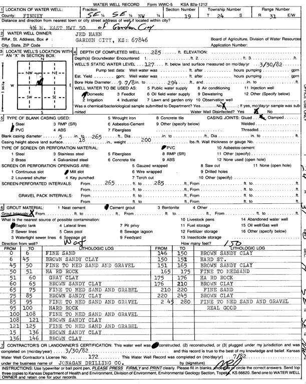
Specific Water Well Detail |
|
|
| Location Info | |||
| Owner: Hahn, Jed | Status: Constructed | ||
| Location: T24S, R31W, Sec. 19, SE SE NW | County: Finney | ||
| Directions: from Garden City, 4.5 mi E on HWY 50 | |||
| Latitude: 37.9537752 | Longitude: -100.7658245 | Datum NAD 27 | |
| Latitude: 37.9537975 | Longitude: -100.76626 | Datum NAD 83 | |
| Longitude and latitude calculated by Survey from township-range-section-quarter calls. Only good to within the quarter call accuracy. | |||
| View well on interactive map | |||
| General Info | ||
| Well Depth: 285 ft. | Elevation: ft. | |
| Static Water Level: 127 ft. | Est. Yield: gpm. | |
| Comp. Date: 30-Mar-1982 | Well Use: Domestic | |
| DWR Applic. #: | Other ID: | |
| Driller Info | ||
| Driller: Jonagan Water Well Service LLC | License #: 172 | |
| Scanned Form | View scan |
|
Chemical Sample Submitted?: No
Water Well disinfected?: | ||
| Ground water encountered: 0 ft. , 0 ft. , 0 ft. | ||
| Pump test data: Well water was 0 ft after 0 hours pumping 0 gpm | ||
| Casing Info | ||
| Casing Type:
Casing Joints: |
Diam: 0 in. to 0 ft
Diam: 0 in. to 0 ft Diam: 0 in. to 0 ft | |
| Casing height above land surface: in
Casing Weight: lbs/ft Wall thickness or gauge no.: | ||
| Screen and Perforation Info | ||
| Screen Type: | Screen Openings: | |
| Screen-perforated intervals | From: 265 ft to 285 ft
From: 0 ft to 0 ft From: 0 ft to 0 ft | |
| Gravel pack intervals | From: ft to ft | |
| Grout Info | ||
| Grout used: | From: 0 to 0 ft
From: 0 to 0 ft From: 0 to 0 ft | |
| Source of Possible Contamination | ||
| Source: | ||
| Direction from well: | Distance: 0 ft | |
| Lithologic Log
(Log data entered by KGS.) | ||
| From: 0 ft. to 6 ft. | fine sand | |
| From: 6 ft. to 45 ft. | brown sandy clay | |
| From: 45 ft. to 50 ft. | fine to medium sand and gravel | |
| From: 50 ft. to 51 ft. | hard rock | |
| From: 51 ft. to 60 ft. | gray clay | |
| From: 60 ft. to 65 ft. | brown sandy clay | |
| From: 65 ft. to 75 ft. | fine to medium sand and gravel | |
| From: 75 ft. to 85 ft. | brown sandy clay | |
| From: 85 ft. to 95 ft. | fine to medium sand and gravel | |
| From: 95 ft. to 100 ft. | hard rock | |
| From: 100 ft. to 108 ft. | fine to medium sand and gravel | |
| From: 108 ft. to 121 ft. | brown sandy clay | |
| From: 121 ft. to 125 ft. | fine to medium sand and gravel | |
| From: 125 ft. to 136 ft. | brown sandy clay | |
| From: 136 ft. to 146 ft. | brown clay | |
| From: 146 ft. to 150 ft. | brown sandy clay | |
| From: 150 ft. to 151 ft. | hard st. | |
| From: 151 ft. to 165 ft. | brown sandy clay | |
| From: 165 ft. to 175 ft. | fine to medium sand | |
| From: 175 ft. to 176 ft. | hard rock | |
| From: 176 ft. to 210 ft. | brown clay | |
| From: 210 ft. to 220 ft. | fine sand | |
| From: 220 ft. to 245 ft. | brown clay | |
| From: 245 ft. to 280 ft. | fine to medium sand and gravel real good | |