|
|
|
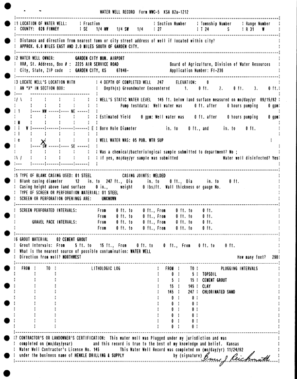
Specific Water Well Detail |
|
|
| Location Info | |||
| Owner: Garden City Municipal Airport | Status: Plugged | ||
| Location: T24S, R31W, Sec. 27, SE NW SW | County: Finney | ||
| Directions: from Garden City, 6 mi E and 2 mi S | |||
| Latitude: 37.9349842 | Longitude: -100.7156081 | Datum NAD 27 | |
| Latitude: 37.9350063 | Longitude: -100.716042 | Datum NAD 83 | |
| Longitude and latitude calculated by Survey from township-range-section-quarter calls. Only good to within the quarter call accuracy. | |||
| View well on interactive map | |||
| General Info | ||
| Well Depth: 247 ft. | Elevation: ft. | |
| Static Water Level: 145 ft. | Est. Yield: gpm. | |
| Comp. Date: 24-Nov-1992 | Well Use: Public Water Supply | |
| DWR Applic. #: FI-236 | Other ID: | |
| Links | |
| No Wizard information available. | |
| View info from WIMAS Water Right Data base... | |
| Driller Info | ||
| Driller: Hydro Resources Mid Continent, Inc. | License #: 145 | |
| Scanned Form | View scan |
| Casing Info | ||
|
Casing Type: Steel
Diam: 12 in. Casing height above land surface: in | ||
| Grout Info | ||
| Grout used: Cement grout | From: 5 to 15 ft
From: 0 to 0 ft From: 0 to 0 ft | |
| Source of Possible Contamination | ||
| Source: OTHER | ||
| Direction from well: | Distance: 0 ft | |