|
|
|
Specific Water Well Detail |
|
|
| Location Info | |||
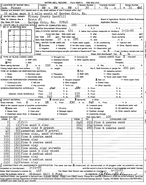
| Owner: Finney County Landfill | Status: Constructed | ||
| Location: T24S, R31W, Sec. 30, NW NW NW | County: Finney | ||
| Directions: from Garden City, 3.5 mi E and 1 mi S | |||
| Latitude: 37.9447637 | Longitude: -100.7726237 | Datum NAD 27 | |
| Latitude: 37.9447862 | Longitude: -100.7730597 | Datum NAD 83 | |
| Longitude and latitude calculated by Survey from township-range-section-quarter calls. Only good to within the quarter call accuracy. | |||
| View well on interactive map | |||
| General Info | ||
| Well Depth: 280 ft. | Elevation: ft. | |
| Static Water Level: 101 ft. | Est. Yield: 28 gpm. | |
| Comp. Date: 31-Mar-1986 | Well Use: Domestic | |
| DWR Applic. #: | Other ID: | |
| Driller Info | ||
| Driller: Midwest Well & Pump | License #: 449 | |
| Scanned Form | View scan |
|
Chemical Sample Submitted?: No
Water Well disinfected?: | ||
| Ground water encountered: 0 ft. , 0 ft. , 0 ft. | ||
| Pump test data: Well water was 0 ft after 0 hours pumping 0 gpm | ||
| Casing Info | ||
| Casing Type: PVC
Casing Joints: |
Diam: 5 in. to 250 ft
Diam: 0 in. to 0 ft Diam: 0 in. to 0 ft | |
| Casing height above land surface: in
Casing Weight: lbs/ft Wall thickness or gauge no.: | ||
| Screen and Perforation Info | ||
| Screen Type: PVC | Screen Openings: Saw cut | |
| Screen-perforated intervals | From: 260 ft to 280 ft
From: 0 ft to 0 ft From: 0 ft to 0 ft | |
| Gravel pack intervals | From: ft to ft | |
| Grout Info | ||
| Grout used: Cement grout | From: 6 to 16 ft
From: 230 to 240 ft From: 0 to 0 ft | |
| Source of Possible Contamination | ||
| Source: Septic Tank | ||
| Direction from well: | Distance: 0 ft | |
| Lithologic Log
(Log data entered by KGS.) | ||
| From: 0 ft. to 2 ft. | fill | |
| From: 2 ft. to 11 ft. | fine sand and clay | |
| From: 11 ft. to 40 ft. | brown clay and gypsum | |
| From: 40 ft. to 60 ft. | cemented sand and gravel | |
| From: 60 ft. to 109 ft. | brown clay, sand streaks | |
| From: 109 ft. to 115 ft. | fine and coarse sand | |
| From: 115 ft. to 120 ft. | brown clay | |
| From: 120 ft. to 135 ft. | fine and coarse sand | |
| From: 135 ft. to 160 ft. | brown clay | |
| From: 160 ft. to 180 ft. | fine sand, clay streaks | |
| From: 180 ft. to 200 ft. | fine sand and clay mixed | |
| From: 200 ft. to 216 ft. | fine and medium sand | |
| From: 216 ft. to 220 ft. | brown clay | |
| From: 220 ft. to 235 ft. | fine and medium sand | |
| From: 235 ft. to 240 ft. | brown clay | |
| From: 240 ft. to 261 ft. | fine and coarse sand | |
| From: 261 ft. to 264 ft. | brown clay | |
| From: 264 ft. to 280 ft. | fine and coarse sand | |