|
|
|
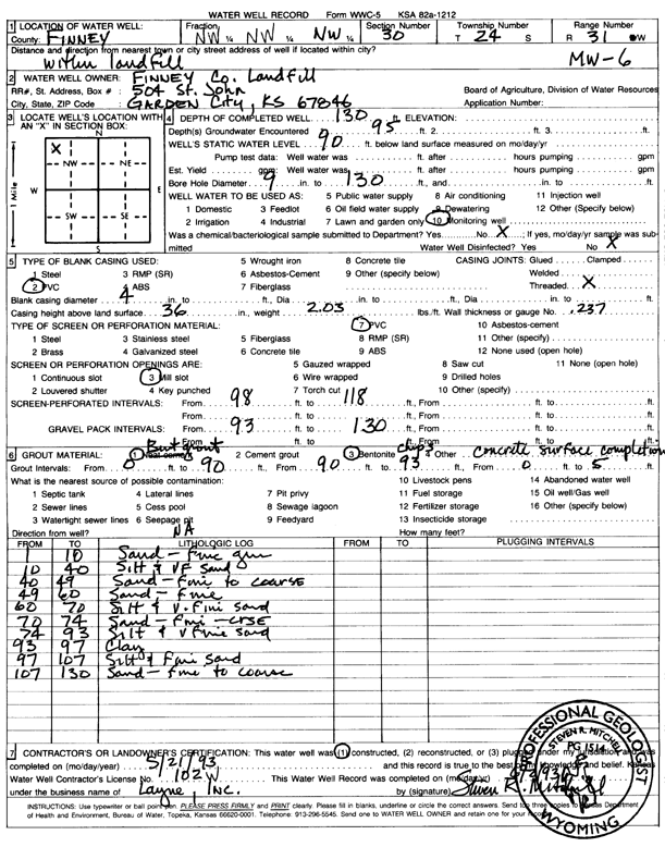
Specific Water Well Detail |
|
|
| Location Info | |||
| Owner: Finney County Landfill | Status: Constructed | ||
| Location: T24S, R31W, Sec. 30, NW NW NW | County: Finney | ||
| Directions: within landfill | |||
| Latitude: 37.9447637 | Longitude: -100.7726237 | Datum NAD 27 | |
| Latitude: 37.9447862 | Longitude: -100.7730597 | Datum NAD 83 | |
| Longitude and latitude calculated by Survey from township-range-section-quarter calls. Only good to within the quarter call accuracy. | |||
| View well on interactive map | |||
| General Info | ||
| Well Depth: 130 ft. | Elevation: ft. | |
| Static Water Level: 90 ft. | Est. Yield: gpm. | |
| Comp. Date: 21-May-1993 | Well Use: Monitoring well/observation/piezometer | |
| DWR Applic. #: | Other ID: MW 6 | |
| Driller Info | ||
| Driller: Layne-Christensen Co. | License #: 102 | |
| Scanned Form | View scan |
|
Chemical Sample Submitted?: No
Water Well disinfected?: | ||
| Ground water encountered: 95 ft. , 0 ft. , 0 ft. | ||
| Pump test data: Well water was 0 ft after 0 hours pumping 0 gpm | ||
| Casing Info | ||
| Casing Type: PVC
Casing Joints: |
Diam: 4 in. to 0 ft
Diam: 0 in. to 0 ft Diam: 0 in. to 0 ft | |
| Casing height above land surface: in
Casing Weight: lbs/ft Wall thickness or gauge no.: | ||
| Screen and Perforation Info | ||
| Screen Type: PVC | Screen Openings: Mill slot | |
| Screen-perforated intervals | From: 98 ft to 118 ft
From: 0 ft to 0 ft From: 0 ft to 0 ft | |
| Gravel pack intervals | From: ft to ft | |
| Grout Info | ||
| Grout used: Neat cement, Bentonite | From: 0 to 5 ft
From: 0 to 90 ft From: 90 to 93 ft | |
| Source of Possible Contamination | ||
| Source: OTHER | ||
| Direction from well: | Distance: 0 ft | |
| Lithologic Log
(Log data entered by KGS.) | ||
| From: 0 ft. to 10 ft. | sand - fine grained | |
| From: 10 ft. to 40 ft. | silt and very fine sand | |
| From: 40 ft. to 49 ft. | sand - fine to coarse | |
| From: 49 ft. to 60 ft. | sand - fine | |
| From: 60 ft. to 70 ft. | silt and very fine sand | |
| From: 70 ft. to 74 ft. | sand - fine-coarse | |
| From: 74 ft. to 93 ft. | silt and v fine sand | |
| From: 93 ft. to 97 ft. | clay | |
| From: 97 ft. to 107 ft. | silt and fine sand | |
| From: 107 ft. to 130 ft. | sand - fine to coarse | |