|
|
|
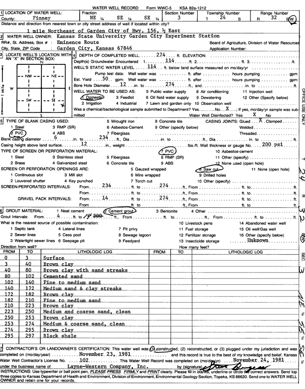
Specific Water Well Detail |
|
|
| Location Info | |||
| Owner: Kansas State University Experiment Station | Status: Constructed | ||
| Location: T24S, R32W, Sec. 3, NE SE SE | County: Finney | ||
| Directions: from Garden City, 1 mi NE on Hwy 156 and 0.5 E | |||
| Latitude: 37.991985 | Longitude: -100.8113862 | Datum NAD 27 | |
| Latitude: 37.9920074 | Longitude: -100.8118232 | Datum NAD 83 | |
| Longitude and latitude calculated by Survey from township-range-section-quarter calls. Only good to within the quarter call accuracy. | |||
| View well on interactive map | |||
| General Info | ||
| Well Depth: 274 ft. | Elevation: ft. | |
| Static Water Level: 114 ft. | Est. Yield: 50 gpm. | |
| Comp. Date: 23-Nov-1981 | Well Use: Domestic | |
| DWR Applic. #: | Other ID: | |
| Driller Info | ||
| Driller: Layne-Christensen Co. | License #: 102 | |
| Scanned Form | View scan |
|
Chemical Sample Submitted?: No
Water Well disinfected?: | ||
| Ground water encountered: 0 ft. , 0 ft. , 0 ft. | ||
| Pump test data: Well water was 0 ft after 0 hours pumping 0 gpm | ||
| Casing Info | ||
| Casing Type:
Casing Joints: |
Diam: 0 in. to 0 ft
Diam: 0 in. to 0 ft Diam: 0 in. to 0 ft | |
| Casing height above land surface: in
Casing Weight: lbs/ft Wall thickness or gauge no.: | ||
| Screen and Perforation Info | ||
| Screen Type: | Screen Openings: | |
| Screen-perforated intervals | From: 234 ft to 274 ft
From: 0 ft to 0 ft From: 0 ft to 0 ft | |
| Gravel pack intervals | From: ft to ft | |
| Grout Info | ||
| Grout used: | From: 0 to 0 ft
From: 0 to 0 ft From: 0 to 0 ft | |
| Source of Possible Contamination | ||
| Source: | ||
| Direction from well: | Distance: 0 ft | |
| Lithologic Log
(Log data entered by KGS.) | ||
| From: 0 ft. to 3 ft. | surface | |
| From: 3 ft. to 40 ft. | brown clay | |
| From: 40 ft. to 80 ft. | brown clay with sand streaks | |
| From: 80 ft. to 102 ft. | cemented sand | |
| From: 102 ft. to 140 ft. | fine to medium sand | |
| From: 140 ft. to 172 ft. | medium sand and clay streaks | |
| From: 172 ft. to 182 ft. | brown clay | |
| From: 182 ft. to 210 ft. | fine to medium sand | |
| From: 210 ft. to 223 ft. | brown clay | |
| From: 223 ft. to 250 ft. | medium and coarse sand, clean | |
| From: 250 ft. to 253 ft. | brown clay | |
| From: 253 ft. to 274 ft. | medium and coarse sand, clean | |
| From: 274 ft. to 295 ft. | brown clay | |
| From: 295 ft. to 297 ft. | black shale | |