|
|
|
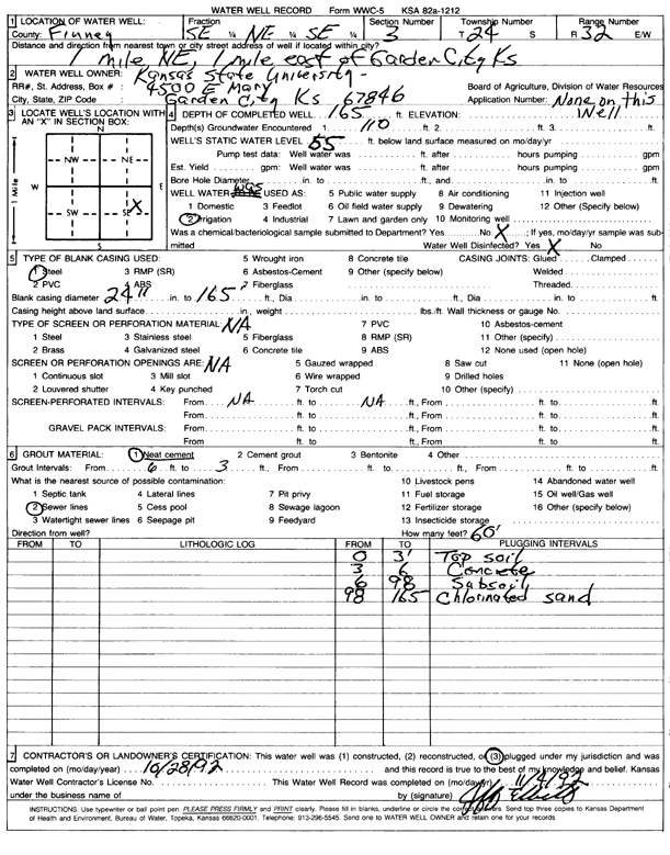
Specific Water Well Detail |
|
|
| Location Info | |||
| Owner: Kansas State University | Status: Plugged | ||
| Location: T24S, R32W, Sec. 3, SE NE SE | County: Finney | ||
| Directions: from Garden City, 1 mi NE and 1 mi E | |||
| Latitude: 37.9937918 | Longitude: -100.8114212 | Datum NAD 27 | |
| Latitude: 37.9938141 | Longitude: -100.8118581 | Datum NAD 83 | |
| Longitude and latitude calculated by Survey from township-range-section-quarter calls. Only good to within the quarter call accuracy. | |||
| View well on interactive map | |||
| General Info | ||
| Well Depth: 165 ft. | Elevation: ft. | |
| Static Water Level: 55 ft. | Est. Yield: gpm. | |
| Comp. Date: 28-Oct-1992 | Well Use: Irrigation | |
| DWR Applic. #: | Other ID: | |
| Links | |
| View info from Wizard Water Level Data base... | |
| No WIMAS information available. | |
| Driller Info | ||
| Driller: KSU | License #: | |
| Scanned Form | View scan |
| Casing Info | ||
|
Casing Type: Steel
Diam: 24 in. Casing height above land surface: in | ||
| Grout Info | ||
| Grout used: Neat cement | From: 3 to 6 ft
From: 0 to 0 ft From: 0 to 0 ft | |
| Source of Possible Contamination | ||
| Source: Sewer lines | ||
| Direction from well: | Distance: 0 ft | |