|
|
|
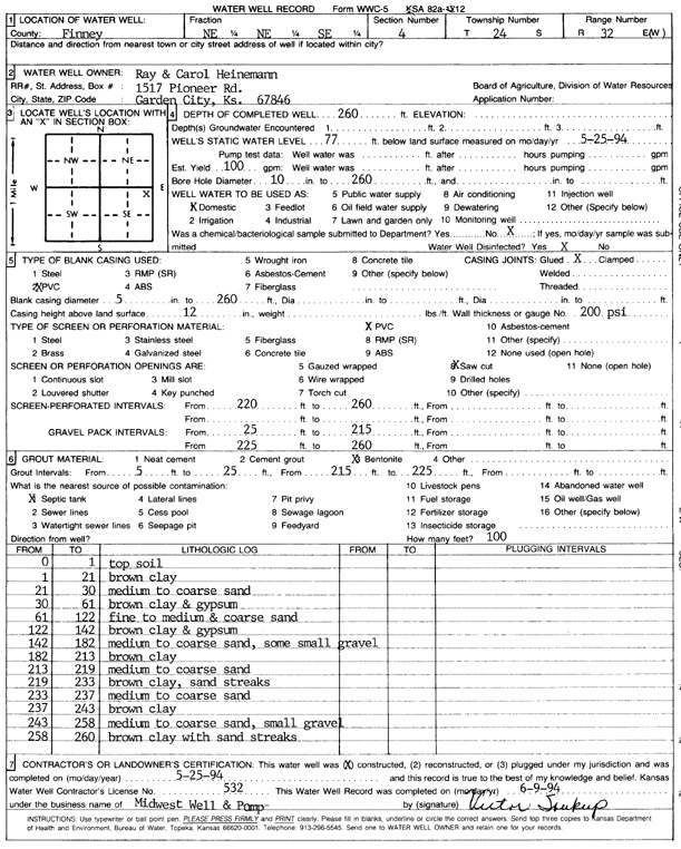
Specific Water Well Detail |
|
|
| Location Info | |||
| Owner: Heinemann, Ray and Carol | Status: Constructed | ||
| Location: T24S, R32W, Sec. 4, NE NE SE | County: Finney | ||
| Directions: | |||
| Latitude: 37.9956571 | Longitude: -100.8297026 | Datum NAD 27 | |
| Latitude: 37.9956797 | Longitude: -100.8301402 | Datum NAD 83 | |
| Longitude and latitude calculated by Survey from township-range-section-quarter calls. Only good to within the quarter call accuracy. | |||
| View well on interactive map | |||
| General Info | ||
| Well Depth: 260 ft. | Elevation: ft. | |
| Static Water Level: 77 ft. | Est. Yield: 100 gpm. | |
| Comp. Date: 25-May-1994 | Well Use: Domestic | |
| DWR Applic. #: | Other ID: | |
| Links | |
| View info from Wizard Water Level Data base... | |
| No WIMAS information available. | |
| Driller Info | ||
| Driller: Midwest Well & Pump, Inc. | License #: 532 | |
| Scanned Form | View scan |
|
Chemical Sample Submitted?: No
Water Well disinfected?: | ||
| Ground water encountered: 0 ft. , 0 ft. , 0 ft. | ||
| Pump test data: Well water was 0 ft after 0 hours pumping 0 gpm | ||
| Casing Info | ||
| Casing Type: PVC
Casing Joints: |
Diam: 5 in. to 260 ft
Diam: 0 in. to 0 ft Diam: 0 in. to 0 ft | |
| Casing height above land surface: in
Casing Weight: lbs/ft Wall thickness or gauge no.: | ||
| Screen and Perforation Info | ||
| Screen Type: PVC | Screen Openings: Saw cut | |
| Screen-perforated intervals | From: 220 ft to 260 ft
From: 0 ft to 0 ft From: 0 ft to 0 ft | |
| Gravel pack intervals | From: ft to ft | |
| Grout Info | ||
| Grout used: Bentonite | From: 5 to 25 ft
From: 215 to 225 ft From: 0 to 0 ft | |
| Source of Possible Contamination | ||
| Source: Septic Tank | ||
| Direction from well: | Distance: 0 ft | |
| Lithologic Log
(Log data entered by KGS.) | ||
| From: 0 ft. to 1 ft. | top soil | |
| From: 1 ft. to 21 ft. | brown clay | |
| From: 21 ft. to 30 ft. | medium to coarse sand | |
| From: 30 ft. to 61 ft. | brown clay and gypsum | |
| From: 61 ft. to 122 ft. | fine to medium and coarse sand | |
| From: 122 ft. to 142 ft. | brown clay and gypsum | |
| From: 142 ft. to 182 ft. | medium to coarse sand, some small gravel | |
| From: 182 ft. to 213 ft. | brown clay | |
| From: 213 ft. to 219 ft. | medium to coarse sand | |
| From: 219 ft. to 233 ft. | brown clay, sand streaks | |
| From: 233 ft. to 237 ft. | medium to coarse sand | |
| From: 237 ft. to 243 ft. | brown clay | |
| From: 243 ft. to 258 ft. | medium to coarse sand, small gravel | |
| From: 258 ft. to 260 ft. | brown clay with sand streaks | |