|
|
|
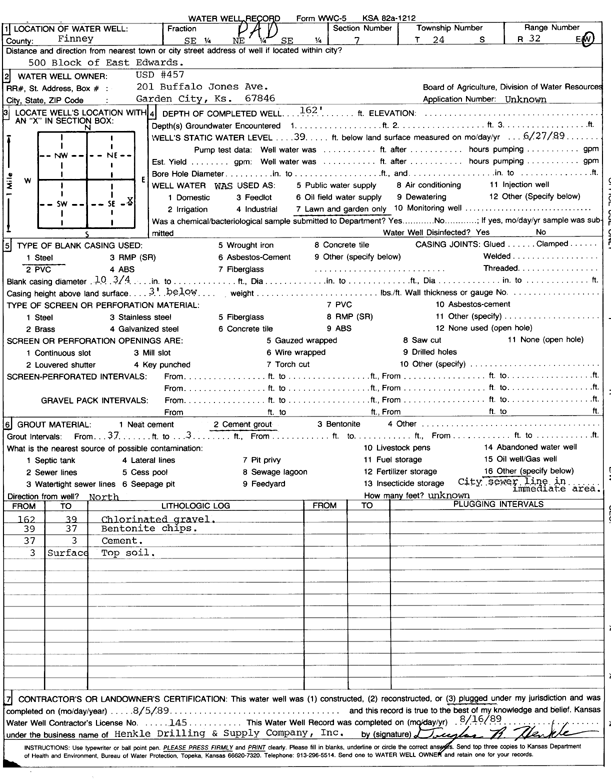
Specific Water Well Detail |
|
|
| Location Info | |||
| Owner: USD 457 | Status: Plugged | ||
| Location: T24S, R32W, Sec. 7, SE NE SE | County: Finney | ||
| Directions: 500 block of E Edwards | |||
| Latitude: 37.9795921 | Longitude: -100.8661512 | Datum NAD 27 | |
| Latitude: 37.9796151 | Longitude: -100.8665905 | Datum NAD 83 | |
| Longitude and latitude calculated by Survey from township-range-section-quarter calls. Only good to within the quarter call accuracy. | |||
| View well on interactive map | |||
| General Info | ||
| Well Depth: 162 ft. | Elevation: ft. | |
| Static Water Level: 39 ft. | Est. Yield: gpm. | |
| Comp. Date: 05-Aug-1989 | Well Use: Domestic, Lawn and Garden | |
| DWR Applic. #: | Other ID: | |
| Driller Info | ||
| Driller: Hydro Res. Mid Continent #145 | License #: 145 | |
| Scanned Form | View scan |
| Casing Info | ||
|
Casing Type: PVC
Diam: 10 in. Casing height above land surface: in | ||
| Grout Info | ||
| Grout used: Cement grout | From: 3 to 37 ft
From: 0 to 0 ft From: 0 to 0 ft | |
| Source of Possible Contamination | ||
| Source: OTHER | ||
| Direction from well: | Distance: 0 ft | |