|
|
|
Specific Water Well Detail |
|
|
| Location Info | |||
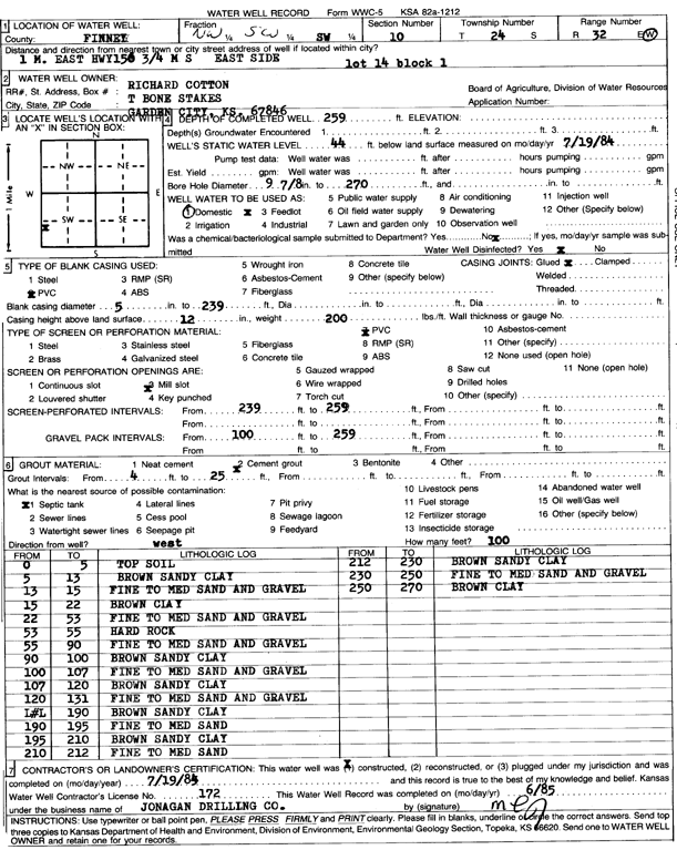
| Owner: Cotton, Richard | Status: Constructed | ||
| Location: T24S, R32W, Sec. 10, NW SW SW | County: Finney | ||
| Directions: 1 mi E HWY 156, .75 mi S, E side (lot 14 block 1) | |||
| Latitude: 37.9775423 | Longitude: -100.827234 | Datum NAD 27 | |
| Latitude: 37.977565 | Longitude: -100.8276718 | Datum NAD 83 | |
| Longitude and latitude calculated by Survey from township-range-section-quarter calls. Only good to within the quarter call accuracy. | |||
| View well on interactive map | |||
| General Info | ||
| Well Depth: 259 ft. | Elevation: ft. | |
| Static Water Level: 44 ft. | Est. Yield: gpm. | |
| Comp. Date: 19-Jul-1985 | Well Use: Domestic | |
| DWR Applic. #: | Other ID: | |
| Driller Info | ||
| Driller: Jonagan Water Well Service LLC | License #: 172 | |
| Scanned Form | View scan |
|
Chemical Sample Submitted?: No
Water Well disinfected?: | ||
| Ground water encountered: 0 ft. , 0 ft. , 0 ft. | ||
| Pump test data: Well water was 0 ft after 0 hours pumping 0 gpm | ||
| Casing Info | ||
| Casing Type: PVC
Casing Joints: |
Diam: 5 in. to 239 ft
Diam: 0 in. to 0 ft Diam: 0 in. to 0 ft | |
| Casing height above land surface: in
Casing Weight: lbs/ft Wall thickness or gauge no.: | ||
| Screen and Perforation Info | ||
| Screen Type: PVC | Screen Openings: Mill slot | |
| Screen-perforated intervals | From: 239 ft to 259 ft
From: 0 ft to 0 ft From: 0 ft to 0 ft | |
| Gravel pack intervals | From: ft to ft | |
| Grout Info | ||
| Grout used: Cement grout | From: 4 to 25 ft
From: 0 to 0 ft From: 0 to 0 ft | |
| Source of Possible Contamination | ||
| Source: Septic Tank | ||
| Direction from well: | Distance: 0 ft | |
| Lithologic Log
(Log data entered by KGS.) | ||
| From: 0 ft. to 5 ft. | top soil | |
| From: 5 ft. to 13 ft. | brown sandy clay | |
| From: 13 ft. to 15 ft. | fine to medium sand and gravel | |
| From: 15 ft. to 22 ft. | brown clay | |
| From: 22 ft. to 53 ft. | fine to medium sand and gravel | |
| From: 53 ft. to 55 ft. | hard rock | |
| From: 55 ft. to 90 ft. | fine to medium sand and gravel | |
| From: 90 ft. to 100 ft. | brown sandy clay | |
| From: 100 ft. to 107 ft. | fine to medium sand and gravel | |
| From: 107 ft. to 120 ft. | brown sandy clay | |
| From: 120 ft. to 131 ft. | fine to medium sand and gravel | |
| From: 131 ft. to 190 ft. | brown sandy clay | |
| From: 190 ft. to 195 ft. | fine to medium sand | |
| From: 195 ft. to 210 ft. | brown sandy clay | |
| From: 210 ft. to 212 ft. | fine to medium sand | |
| From: 212 ft. to 230 ft. | brown sandy clay | |
| From: 230 ft. to 250 ft. | fine to medium sand and gravel | |
| From: 250 ft. to 270 ft. | brown clay | |