|
|
|
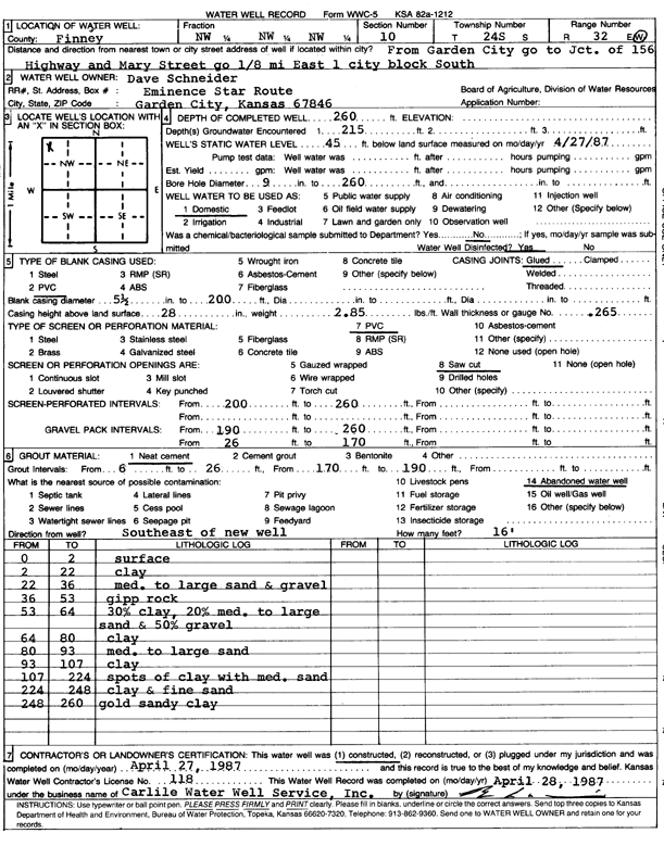
Specific Water Well Detail |
|
|
| Location Info | |||
| Owner: Schneider, Dave | Status: Constructed | ||
| Location: T24S, R32W, Sec. 10, NW NW NW | County: Finney | ||
| Directions: from 156 Hwy and Mary St in Garden City, 0.13 mi E and 1 city block S | |||
| Latitude: 37.9883975 | Longitude: -100.8272601 | Datum NAD 27 | |
| Latitude: 37.98842 | Longitude: -100.8276978 | Datum NAD 83 | |
| Longitude and latitude calculated by Survey from township-range-section-quarter calls. Only good to within the quarter call accuracy. | |||
| View well on interactive map | |||
| General Info | ||
| Well Depth: 260 ft. | Elevation: ft. | |
| Static Water Level: 45 ft. | Est. Yield: gpm. | |
| Comp. Date: 27-Apr-1987 | Well Use: Domestic | |
| DWR Applic. #: | Other ID: | |
| Driller Info | ||
| Driller: Bernard E. Carlile Water Well Service, Inc. | License #: 118 | |
| Scanned Form | View scan |
|
Chemical Sample Submitted?: No
Water Well disinfected?: | ||
| Ground water encountered: 215 ft. , 0 ft. , 0 ft. | ||
| Pump test data: Well water was 0 ft after 0 hours pumping 0 gpm | ||
| Casing Info | ||
| Casing Type:
Casing Joints: |
Diam: 5 in. to 200 ft
Diam: 0 in. to 0 ft Diam: 0 in. to 0 ft | |
| Casing height above land surface: in
Casing Weight: lbs/ft Wall thickness or gauge no.: | ||
| Screen and Perforation Info | ||
| Screen Type: PVC | Screen Openings: Saw cut | |
| Screen-perforated intervals | From: 200 ft to 260 ft
From: 0 ft to 0 ft From: 0 ft to 0 ft | |
| Gravel pack intervals | From: ft to ft | |
| Grout Info | ||
| Grout used: Neat cement | From: 60 to 206 ft
From: 170 to 190 ft From: 0 to 0 ft | |
| Source of Possible Contamination | ||
| Source: Abandoned water well | ||
| Direction from well: | Distance: 0 ft | |
| Lithologic Log
(Log data entered by KGS.) | ||
| From: 0 ft. to 2 ft. | surface | |
| From: 2 ft. to 22 ft. | clay | |
| From: 22 ft. to 36 ft. | med. to large sand and gravel | |
| From: 36 ft. to 53 ft. | gyp rock | |
| From: 53 ft. to 64 ft. | 30% clay, 20% med. to large sand and 50% gravel | |
| From: 64 ft. to 80 ft. | clay | |
| From: 80 ft. to 93 ft. | med. to large sand | |
| From: 93 ft. to 107 ft. | clay | |
| From: 107 ft. to 224 ft. | spots of clay with medium sand | |
| From: 224 ft. to 248 ft. | clay and fine sand | |
| From: 248 ft. to 260 ft. | gold sandy clay | |