|
|
|
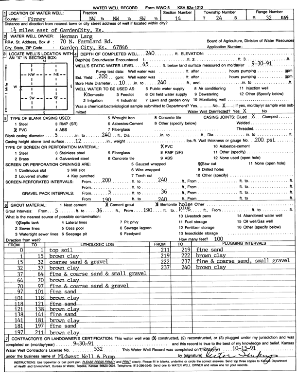
Specific Water Well Detail |
|
|
| Location Info | |||
| Owner: Lang, Herman | Status: Constructed | ||
| Location: T24S, R32W, Sec. 14, NW NW SW | County: Finney | ||
| Directions: from Garden City, 1.5 mi E | |||
| Latitude: 37.9665984 | Longitude: -100.8090308 | Datum NAD 27 | |
| Latitude: 37.9666209 | Longitude: -100.8094679 | Datum NAD 83 | |
| Longitude and latitude calculated by Survey from township-range-section-quarter calls. Only good to within the quarter call accuracy. | |||
| View well on interactive map | |||
| General Info | ||
| Well Depth: 240 ft. | Elevation: ft. | |
| Static Water Level: 45 ft. | Est. Yield: 200 gpm. | |
| Comp. Date: 30-Sep-1991 | Well Use: Domestic | |
| DWR Applic. #: | Other ID: | |
| Driller Info | ||
| Driller: Midwest Well & Pump, Inc. | License #: 532 | |
| Scanned Form | View scan |
|
Chemical Sample Submitted?: No
Water Well disinfected?: | ||
| Ground water encountered: 0 ft. , 0 ft. , 0 ft. | ||
| Pump test data: Well water was 0 ft after 0 hours pumping 0 gpm | ||
| Casing Info | ||
| Casing Type: PVC
Casing Joints: |
Diam: 5 in. to 240 ft
Diam: 0 in. to 0 ft Diam: 0 in. to 0 ft | |
| Casing height above land surface: in
Casing Weight: lbs/ft Wall thickness or gauge no.: | ||
| Screen and Perforation Info | ||
| Screen Type: PVC | Screen Openings: Saw cut | |
| Screen-perforated intervals | From: 0 ft to 240 ft
From: 0 ft to 0 ft From: 0 ft to 0 ft | |
| Gravel pack intervals | From: ft to ft | |
| Grout Info | ||
| Grout used: Cement grout, Bentonite | From: 36 to 190 ft
From: 0 to 0 ft From: 0 to 0 ft | |
| Source of Possible Contamination | ||
| Source: Septic Tank | ||
| Direction from well: | Distance: 0 ft | |
| Lithologic Log
(Log data entered by KGS.) | ||
| From: 0 ft. to 1 ft. | top soil | |
| From: 1 ft. to 15 ft. | brown clay | |
| From: 15 ft. to 32 ft. | coarse sand and gravel | |
| From: 32 ft. to 37 ft. | brown clay | |
| From: 37 ft. to 64 ft. | fine and coarse sand and small gravel | |
| From: 64 ft. to 70 ft. | brown clay | |
| From: 70 ft. to 97 ft. | fine and coarse sand and gravel | |
| From: 97 ft. to 101 ft. | fine sand | |
| From: 101 ft. to 118 ft. | brown clay | |
| From: 118 ft. to 121 ft. | fine sand | |
| From: 121 ft. to 138 ft. | brown clay | |
| From: 138 ft. to 141 ft. | fine sand | |
| From: 141 ft. to 181 ft. | brown clay | |
| From: 181 ft. to 197 ft. | fine sand | |
| From: 197 ft. to 211 ft. | brown clay | |
| From: 211 ft. to 219 ft. | fine sand | |
| From: 219 ft. to 222 ft. | brown clay | |
| From: 222 ft. to 237 ft. | fine and coarse sand, small gravel | |
| From: 237 ft. to 240 ft. | brown clay | |