|
|
|
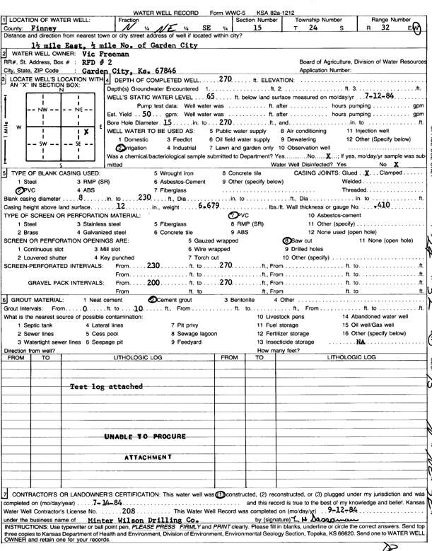
Specific Water Well Detail |
|
|
| Location Info | |||
| Owner: Freeman, Vic | Status: Constructed | ||
| Location: T24S, R32W, Sec. 15, N2 NE SE | County: Finney | ||
| Directions: from Garden City, 1.5 mi E, .5 mi N | |||
| Latitude: 37.9666132 | Longitude: -100.8124525 | Datum NAD 27 | |
| Latitude: 37.9666358 | Longitude: -100.8128898 | Datum NAD 83 | |
| Longitude and latitude calculated by Survey from township-range-section-quarter calls. Only good to within the quarter call accuracy. | |||
| View well on interactive map | |||
| General Info | ||
| Well Depth: 270 ft. | Elevation: ft. | |
| Static Water Level: 65 ft. | Est. Yield: 50 gpm. | |
| Comp. Date: 14-Jul-1984 | Well Use: Irrigation | |
| DWR Applic. #: | Other ID: | |
| Driller Info | ||
| Driller: Minter-Wilson Drlg. Co., Inc. | License #: 208 | |
| Scanned Form | View scan |
|
Chemical Sample Submitted?: No
Water Well disinfected?: | ||
| Ground water encountered: 0 ft. , 0 ft. , 0 ft. | ||
| Pump test data: Well water was 0 ft after 0 hours pumping 0 gpm | ||
| Casing Info | ||
| Casing Type: PVC
Casing Joints: |
Diam: 8 in. to 230 ft
Diam: 0 in. to 0 ft Diam: 0 in. to 0 ft | |
| Casing height above land surface: in
Casing Weight: lbs/ft Wall thickness or gauge no.: | ||
| Screen and Perforation Info | ||
| Screen Type: PVC | Screen Openings: Saw cut | |
| Screen-perforated intervals | From: 230 ft to 270 ft
From: 0 ft to 0 ft From: 0 ft to 0 ft | |
| Gravel pack intervals | From: ft to ft | |
| Grout Info | ||
| Grout used: Cement grout | From: 0 to 10 ft
From: 0 to 0 ft From: 0 to 0 ft | |
| Source of Possible Contamination | ||
| Source: | ||
| Direction from well: | Distance: 0 ft | |
| Lithologic Log
(log data not edited or checked by the KGS.) | ||
| From: 0 ft. to 3 ft. | Type: CLAY | |
| From: 3 ft. to 18 ft. | Type: SAND & GRAVEL | |
| From: 18 ft. to 32 ft. | Type: SANDY CLAY | |
| From: 32 ft. to 39 ft. | Type: SAND & GRAVEL | |
| From: 39 ft. to 130 ft. | Type: SANDY CLAY | |
| From: 130 ft. to 138 ft. | Type: SAND | |
| From: 138 ft. to 170 ft. | Type: SANDY CLAY | |
| From: 170 ft. to 212 ft. | Type: SAND | |
| From: 212 ft. to 215 ft. | Type: SANDY CLAY | |
| From: 215 ft. to 231 ft. | Type: SAND & GRAVEL | |
| From: 231 ft. to 269 ft. | Type: CLAY | |
| From: 269 ft. to 275 ft. | Type: SHALE | |