|
|
|
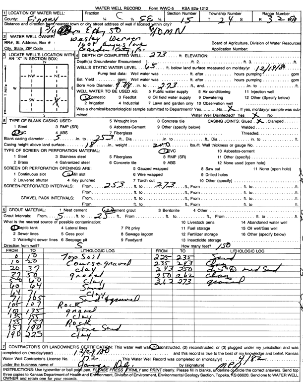
Specific Water Well Detail |
|
|
| Location Info | |||
| Owner: Werner, Wesley | Status: Constructed | ||
| Location: T24S, R32W, Sec. 15, C SE | County: Finney | ||
| Directions: 1.75 mi E on HWY 50, .6 mi N | |||
| Latitude: 37.9639264 | Longitude: -100.8147531 | Datum NAD 27 | |
| Latitude: 37.9639491 | Longitude: -100.8151905 | Datum NAD 83 | |
| Longitude and latitude calculated by Survey from township-range-section-quarter calls. Only good to within the quarter call accuracy. | |||
| View well on interactive map | |||
| General Info | ||
| Well Depth: 273 ft. | Elevation: ft. | |
| Static Water Level: 65 ft. | Est. Yield: gpm. | |
| Comp. Date: 29-Dec-1980 | Well Use: Domestic | |
| DWR Applic. #: | Other ID: | |
| Driller Info | ||
| Driller: Jonagan Water Well Service LLC | License #: 172 | |
| Scanned Form | View scan |
|
Chemical Sample Submitted?: No
Water Well disinfected?: | ||
| Ground water encountered: 0 ft. , 0 ft. , 0 ft. | ||
| Pump test data: Well water was 0 ft after 0 hours pumping 0 gpm | ||
| Casing Info | ||
| Casing Type:
Casing Joints: |
Diam: 0 in. to 0 ft
Diam: 0 in. to 0 ft Diam: 0 in. to 0 ft | |
| Casing height above land surface: in
Casing Weight: lbs/ft Wall thickness or gauge no.: | ||
| Screen and Perforation Info | ||
| Screen Type: | Screen Openings: | |
| Screen-perforated intervals | From: 253 ft to 273 ft
From: 0 ft to 0 ft From: 0 ft to 0 ft | |
| Gravel pack intervals | From: ft to ft | |
| Grout Info | ||
| Grout used: | From: 0 to 0 ft
From: 0 to 0 ft From: 0 to 0 ft | |
| Source of Possible Contamination | ||
| Source: | ||
| Direction from well: | Distance: 0 ft | |
| Lithologic Log
(Log data entered by KGS.) | ||
| From: 0 ft. to 10 ft. | top soil | |
| From: 10 ft. to 20 ft. | coarse gravel | |
| From: 20 ft. to 37 ft. | clay | |
| From: 37 ft. to 50 ft. | gravel | |
| From: 50 ft. to 60 ft. | clay | |
| From: 60 ft. to 64 ft. | sand | |
| From: 64 ft. to 71 ft. | clay | |
| From: 71 ft. to 105 ft. | sand and gravel | |
| From: 105 ft. to 107 ft. | rock | |
| From: 107 ft. to 135 ft. | gravel | |
| From: 135 ft. to 155 ft. | clay | |
| From: 155 ft. to 157 ft. | rock | |
| From: 157 ft. to 190 ft. | fine sand | |
| From: 190 ft. to 225 ft. | clay | |
| From: 225 ft. to 235 ft. | sand | |
| From: 235 ft. to 243 ft. | clay | |
| From: 243 ft. to 250 ft. | fine to medium sand | |
| From: 250 ft. to 262 ft. | clay | |
| From: 262 ft. to 273 ft. | gravel | |