|
|
|
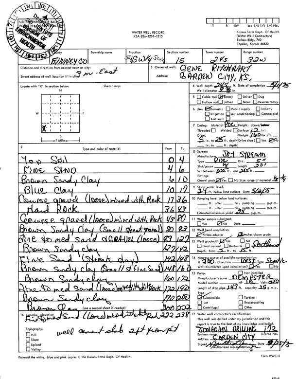
Specific Water Well Detail |
|
|
| Location Info | |||
| Owner: Ritchhart, Gene | Status: Constructed | ||
| Location: T24S, R32W, Sec. 15, SW SW SW | County: Finney | ||
| Directions: from Garden City, 3 mi E | |||
| Latitude: 37.9612729 | Longitude: -100.8273014 | Datum NAD 27 | |
| Latitude: 37.9612957 | Longitude: -100.8277394 | Datum NAD 83 | |
| Longitude and latitude calculated by Survey from township-range-section-quarter calls. Only good to within the quarter call accuracy. | |||
| View well on interactive map | |||
| General Info | ||
| Well Depth: 245 ft. | Elevation: ft. | |
| Static Water Level: 24 ft. | Est. Yield: 25 gpm. | |
| Comp. Date: 01-May-1975 | Well Use: Domestic | |
| DWR Applic. #: | Other ID: | |
| Driller Info | ||
| Driller: Jonagan Water Well Service LLC | License #: 172 | |
| Scanned Form | View scan |
|
Chemical Sample Submitted?: No
Water Well disinfected?: | ||
| Ground water encountered: 0 ft. , 0 ft. , 0 ft. | ||
| Pump test data: Well water was 0 ft after 0 hours pumping 0 gpm | ||
| Casing Info | ||
| Casing Type:
Casing Joints: |
Diam: 0 in. to 0 ft
Diam: 0 in. to 0 ft Diam: 0 in. to 0 ft | |
| Casing height above land surface: in
Casing Weight: lbs/ft Wall thickness or gauge no.: | ||
| Screen and Perforation Info | ||
| Screen Type: | Screen Openings: | |
| Screen-perforated intervals | From: 225 ft to 245 ft
From: 0 ft to 0 ft From: 0 ft to 0 ft | |
| Gravel pack intervals | From: ft to ft | |
| Grout Info | ||
| Grout used: | From: 0 to 0 ft
From: 0 to 0 ft From: 0 to 0 ft | |
| Source of Possible Contamination | ||
| Source: | ||
| Direction from well: | Distance: 0 ft | |
| Lithologic Log
(Log data entered by KGS.) | ||
| From: 0 ft. to 4 ft. | top soil | |
| From: 4 ft. to 6 ft. | fine sand | |
| From: 6 ft. to 10 ft. | brown sandy clay | |
| From: 10 ft. to 17 ft. | blue clay | |
| From: 17 ft. to 36 ft. | coarse gravel (loose) mixed with rock | |
| From: 36 ft. to 43 ft. | hard rock | |
| From: 43 ft. to 80 ft. | coarse gravel (loose) mixed with rock | |
| From: 80 ft. to 93 ft. | brown sandy clay (small streak gravel) | |
| From: 93 ft. to 127 ft. | fine to medium sand and gravel (loose) | |
| From: 127 ft. to 142 ft. | brown sandy clay | |
| From: 142 ft. to 148 ft. | fine sand (streak clay) | |
| From: 148 ft. to 160 ft. | brown sandy clay (small st fine sand) | |
| From: 160 ft. to 172 ft. | brown sandy clay | |
| From: 172 ft. to 190 ft. | fine to medium sand (loose) mixed with white rock | |
| From: 190 ft. to 200 ft. | brown sandy clay | |
| From: 200 ft. to 222 ft. | brown clay | |
| From: 222 ft. to 238 ft. | fine to medium sand (loose) mixed with white rock | |