|
|
|
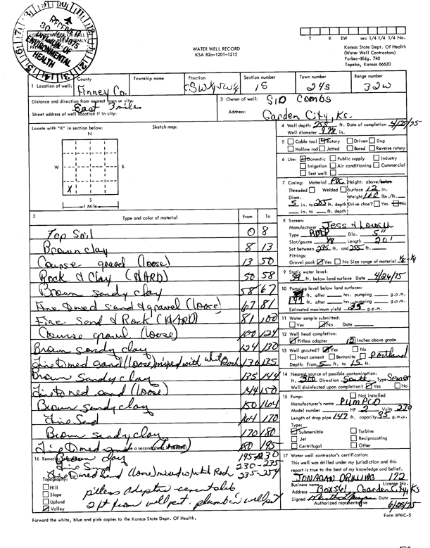
Specific Water Well Detail |
|
|
| Location Info | |||
| Owner: Combs, Sid | Status: Constructed | ||
| Location: T24S, R32W, Sec. 15, C SW SW | County: Finney | ||
| Directions: from Garden City, 3 mi E | |||
| Latitude: 37.9621721 | Longitude: -100.8261574 | Datum NAD 27 | |
| Latitude: 37.9621948 | Longitude: -100.8265953 | Datum NAD 83 | |
| Longitude and latitude calculated by Survey from township-range-section-quarter calls. Only good to within the quarter call accuracy. | |||
| View well on interactive map | |||
| General Info | ||
| Well Depth: 255 ft. | Elevation: ft. | |
| Static Water Level: 39 ft. | Est. Yield: 35 gpm. | |
| Comp. Date: 25-Apr-1975 | Well Use: Domestic | |
| DWR Applic. #: | Other ID: | |
| Driller Info | ||
| Driller: Jonagan Water Well Service LLC | License #: 172 | |
| Scanned Form | View scan |
|
Chemical Sample Submitted?: No
Water Well disinfected?: | ||
| Ground water encountered: 0 ft. , 0 ft. , 0 ft. | ||
| Pump test data: Well water was 0 ft after 0 hours pumping 0 gpm | ||
| Casing Info | ||
| Casing Type:
Casing Joints: |
Diam: 0 in. to 0 ft
Diam: 0 in. to 0 ft Diam: 0 in. to 0 ft | |
| Casing height above land surface: in
Casing Weight: lbs/ft Wall thickness or gauge no.: | ||
| Screen and Perforation Info | ||
| Screen Type: | Screen Openings: | |
| Screen-perforated intervals | From: 235 ft to 255 ft
From: 0 ft to 0 ft From: 0 ft to 0 ft | |
| Gravel pack intervals | From: ft to ft | |
| Grout Info | ||
| Grout used: | From: 0 to 0 ft
From: 0 to 0 ft From: 0 to 0 ft | |
| Source of Possible Contamination | ||
| Source: | ||
| Direction from well: | Distance: 0 ft | |
| Lithologic Log
(Log data entered by KGS.) | ||
| From: 0 ft. to 8 ft. | top soil | |
| From: 8 ft. to 13 ft. | brown clay | |
| From: 13 ft. to 50 ft. | coarse gravel (loose) | |
| From: 50 ft. to 58 ft. | rock and clay (hard) | |
| From: 58 ft. to 67 ft. | brown sandy clay | |
| From: 67 ft. to 81 ft. | fine to medium sand and gravel (loose) | |
| From: 81 ft. to 100 ft. | fine sand and rock (hard) | |
| From: 100 ft. to 124 ft. | coarse gravel (loose) | |
| From: 124 ft. to 130 ft. | brown sandy clay | |
| From: 130 ft. to 135 ft. | fine to medium sand (loose) mixed with white rock | |
| From: 135 ft. to 144 ft. | brown sandy clay | |
| From: 144 ft. to 150 ft. | fine to medium sand (loose) | |
| From: 150 ft. to 164 ft. | brown sandy clay | |
| From: 164 ft. to 170 ft. | fine sand | |
| From: 170 ft. to 180 ft. | brown sandy clay | |
| From: 180 ft. to 195 ft. | fine to medium sand (loose) | |
| From: 195 ft. to 230 ft. | brown clay | |
| From: 230 ft. to 235 ft. | fine sand | |
| From: 235 ft. to 254 ft. | fine to medium sand (loose) mixed with white rock | |