|
|
|
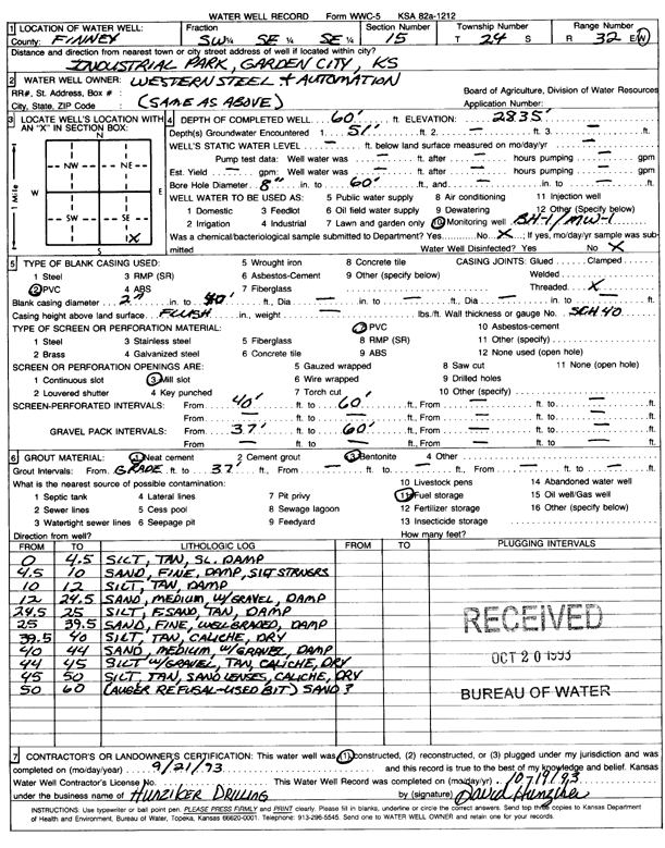
Specific Water Well Detail |
|
|
| Location Info | |||
| Owner: Western Steel & Automation | Status: Constructed | ||
| Location: T24S, R32W, Sec. 15, SW SE SE | County: Finney | ||
| Directions: Industrial Park, Garden City | |||
| Latitude: 37.9612229 | Longitude: -100.813635 | Datum NAD 27 | |
| Latitude: 37.9612455 | Longitude: -100.8140724 | Datum NAD 83 | |
| Longitude and latitude calculated by Survey from township-range-section-quarter calls. Only good to within the quarter call accuracy. | |||
| View well on interactive map | |||
| General Info | ||
| Well Depth: 60 ft. | Elevation: 2835 ft. | |
| Static Water Level: 0 ft. | Est. Yield: gpm. | |
| Comp. Date: 21-Sep-1993 | Well Use: Monitoring well/observation/piezometer | |
| DWR Applic. #: | Other ID: MW 1 | |
| Driller Info | ||
| Driller: unknown | License #: | |
| Scanned Form | View scan |
|
Chemical Sample Submitted?: No
Water Well disinfected?: | ||
| Ground water encountered: 50 ft. , 0 ft. , 0 ft. | ||
| Pump test data: Well water was 0 ft after 0 hours pumping 0 gpm | ||
| Casing Info | ||
| Casing Type: PVC
Casing Joints: |
Diam: 2 in. to 40 ft
Diam: 0 in. to 0 ft Diam: 0 in. to 0 ft | |
| Casing height above land surface: in
Casing Weight: lbs/ft Wall thickness or gauge no.: | ||
| Screen and Perforation Info | ||
| Screen Type: PVC | Screen Openings: Mill slot | |
| Screen-perforated intervals | From: 40 ft to 60 ft
From: 0 ft to 0 ft From: 0 ft to 0 ft | |
| Gravel pack intervals | From: ft to ft | |
| Grout Info | ||
| Grout used: Neat cement, Bentonite | From: 0 to 37 ft
From: 0 to 0 ft From: 0 to 0 ft | |
| Source of Possible Contamination | ||
| Source: Fuel storage | ||
| Direction from well: | Distance: 0 ft | |
| Lithologic Log
(Log data entered by KGS.) | ||
| From: 0 ft. to 4.5 ft. | silt, tan, slightly damp | |
| From: 4.5 ft. to 10 ft. | sand, fine, damp, silt stringers | |
| From: 10 ft. to 12 ft. | silt, tan, damp | |
| From: 12 ft. to 24.5 ft. | sand, medium, with gravel, damp | |
| From: 24.5 ft. to 25 ft. | silt, f. sand, tan, damp | |
| From: 25 ft. to 39.5 ft. | sand, fine, well graded, damp | |
| From: 39.5 ft. to 40 ft. | silt, tan, caliche, dry | |
| From: 40 ft. to 44 ft. | sand, medium, with gravel, damp | |
| From: 44 ft. to 45 ft. | silt with gravel, tan, caliche, dry | |
| From: 45 ft. to 50 ft. | silt, tan, sand lenses, caliche, dry | |
| From: 50 ft. to 60 ft. | sand? | |