|
|
|
Specific Water Well Detail |
|
|
| Location Info | |||
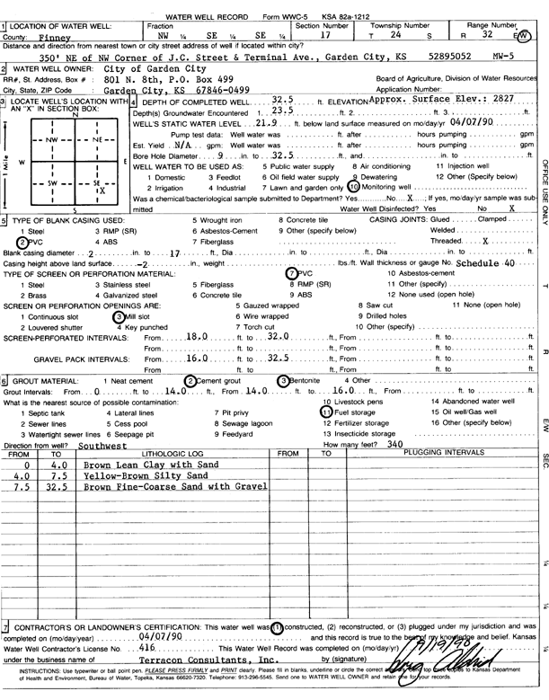
| Owner: City of Garden City | Status: Constructed | ||
| Location: T24S, R32W, Sec. 17, NW SE SE | County: Finney | ||
| Directions: 350 ft NE of NW corner of JC St and Terminal Ave, Garden City | |||
| Latitude: 37.9632069 | Longitude: -100.8501311 | Datum NAD 27 | |
| Latitude: 37.9632299 | Longitude: -100.85057 | Datum NAD 83 | |
| Longitude and latitude calculated by Survey from township-range-section-quarter calls. Only good to within the quarter call accuracy. | |||
| View well on interactive map | |||
| General Info | ||
| Well Depth: 32.5 ft. | Elevation: 2827 ft. | |
| Static Water Level: 21.9 ft. | Est. Yield: gpm. | |
| Comp. Date: 07-Apr-1990 | Well Use: Monitoring well/observation/piezometer | |
| DWR Applic. #: | Other ID: MW 5 | |
| Driller Info | ||
| Driller: Terracon, Inc. | License #: 416 | |
| Scanned Form | View scan |
|
Chemical Sample Submitted?: No
Water Well disinfected?: | ||
| Ground water encountered: 23 ft. , 0 ft. , 0 ft. | ||
| Pump test data: Well water was 0 ft after 0 hours pumping 0 gpm | ||
| Casing Info | ||
| Casing Type: PVC
Casing Joints: |
Diam: 2 in. to 17 ft
Diam: 0 in. to 0 ft Diam: 0 in. to 0 ft | |
| Casing height above land surface: in
Casing Weight: lbs/ft Wall thickness or gauge no.: | ||
| Screen and Perforation Info | ||
| Screen Type: PVC | Screen Openings: Mill slot | |
| Screen-perforated intervals | From: 18 ft to 32 ft
From: 0 ft to 0 ft From: 0 ft to 0 ft | |
| Gravel pack intervals | From: ft to ft | |
| Grout Info | ||
| Grout used: Cement grout, Bentonite | From: 0 to 14 ft
From: 14 to 16 ft From: 0 to 0 ft | |
| Source of Possible Contamination | ||
| Source: Fuel storage | ||
| Direction from well: | Distance: 0 ft | |
| Lithologic Log
(Log data entered by KGS.) | ||
| From: 0 ft. to 4 ft. | brown lean clay with sand | |
| From: 4 ft. to 7.5 ft. | yellow-brown silty sand | |
| From: 7.5 ft. to 32.5 ft. | brown fine-coarse sand with gravel | |