|
|
|
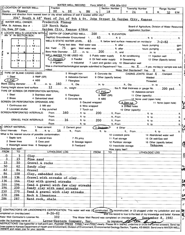
Specific Water Well Detail |
|
|
| Location Info | |||
| Owner: Finnup, Frederick | Status: Constructed | ||
| Location: T24S, R32W, Sec. 18, SE SE NW | County: Finney | ||
| Directions: from 9th and St John St, 204 feet S and 48 feet W, Garden City | |||
| Latitude: 37.9686624 | Longitude: -100.8750814 | Datum NAD 27 | |
| Latitude: 37.9686855 | Longitude: -100.8755212 | Datum NAD 83 | |
| Longitude and latitude calculated by Survey from township-range-section-quarter calls. Only good to within the quarter call accuracy. | |||
| View well on interactive map | |||
| General Info | ||
| Well Depth: 200 ft. | Elevation: ft. | |
| Static Water Level: 65 ft. | Est. Yield: 75 gpm. | |
| Comp. Date: 26-Aug-1982 | Well Use: Domestic | |
| DWR Applic. #: | Other ID: | |
| Driller Info | ||
| Driller: Layne-Christensen Co. | License #: 102 | |
| Scanned Form | View scan |
|
Chemical Sample Submitted?: No
Water Well disinfected?: | ||
| Ground water encountered: 0 ft. , 0 ft. , 0 ft. | ||
| Pump test data: Well water was 0 ft after 0 hours pumping 0 gpm | ||
| Casing Info | ||
| Casing Type:
Casing Joints: |
Diam: 0 in. to 0 ft
Diam: 0 in. to 0 ft Diam: 0 in. to 0 ft | |
| Casing height above land surface: in
Casing Weight: lbs/ft Wall thickness or gauge no.: | ||
| Screen and Perforation Info | ||
| Screen Type: | Screen Openings: | |
| Screen-perforated intervals | From: 160 ft to 200 ft
From: 0 ft to 0 ft From: 0 ft to 0 ft | |
| Gravel pack intervals | From: ft to ft | |
| Grout Info | ||
| Grout used: | From: 0 to 0 ft
From: 0 to 0 ft From: 0 to 0 ft | |
| Source of Possible Contamination | ||
| Source: | ||
| Direction from well: | Distance: 0 ft | |
| Lithologic Log
(Log data entered by KGS.) | ||
| From: 0 ft. to 3 ft. | clay | |
| From: 3 ft. to 15 ft. | fine sand | |
| From: 15 ft. to 50 ft. | gravel and rocks | |
| From: 50 ft. to 62 ft. | sandy clay | |
| From: 62 ft. to 84 ft. | gravel | |
| From: 84 ft. to 108 ft. | clay, embedded rock | |
| From: 108 ft. to 136 ft. | gravel with streaks of clay | |
| From: 136 ft. to 164 ft. | clay with gravel streaks | |
| From: 164 ft. to 196 ft. | sand and gravel with few clay streaks | |
| From: 196 ft. to 250 ft. | sandy clay with sand streaks | |
| From: 250 ft. to 270 ft. | sand and gravel with clay streaks | |
| From: 270 ft. to 286 ft. | rock and limestone | |
| From: 286 ft. to 287 ft. | hard rock, shale | |