|
|
|
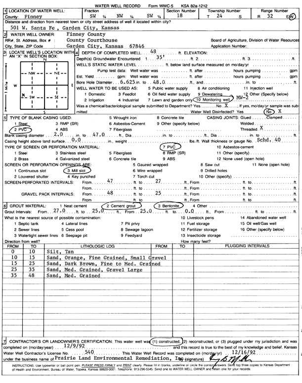
Specific Water Well Detail |
|
|
| Location Info | |||
| Owner: Finney County | Status: Constructed | ||
| Location: T24S, R32W, Sec. 18, SW NW SW | County: Finney | ||
| Directions: 501 W Santa Fe, Garden City | |||
| Latitude: 37.9650267 | Longitude: -100.8817938 | Datum NAD 27 | |
| Latitude: 37.9650499 | Longitude: -100.8822338 | Datum NAD 83 | |
| Longitude and latitude calculated by Survey from township-range-section-quarter calls. Only good to within the quarter call accuracy. | |||
| View well on interactive map | |||
| General Info | ||
| Well Depth: 48 ft. | Elevation: ft. | |
| Static Water Level: ft. | Est. Yield: gpm. | |
| Comp. Date: 09-Dec-1992 | Well Use: Monitoring well/observation/piezometer | |
| DWR Applic. #: | Other ID: MW 2 | |
| Driller Info | ||
| Driller: Prairie Land Environmental Remed. | License #: 540 | |
| Scanned Form | View scan |
|
Chemical Sample Submitted?: No
Water Well disinfected?: | ||
| Ground water encountered: 35 ft. , 0 ft. , 0 ft. | ||
| Pump test data: Well water was 0 ft after 0 hours pumping 0 gpm | ||
| Casing Info | ||
| Casing Type: PVC
Casing Joints: |
Diam: 2 in. to 45 ft
Diam: 0 in. to 0 ft Diam: 0 in. to 0 ft | |
| Casing height above land surface: in
Casing Weight: lbs/ft Wall thickness or gauge no.: | ||
| Screen and Perforation Info | ||
| Screen Type: PVC | Screen Openings: Mill slot | |
| Screen-perforated intervals | From: 25 ft to 45 ft
From: 0 ft to 0 ft From: 0 ft to 0 ft | |
| Gravel pack intervals | From: ft to ft | |
| Grout Info | ||
| Grout used: Cement grout, Bentonite | From: 0 to 21 ft
From: 21 to 23 ft From: 0 to 0 ft | |
| Source of Possible Contamination | ||
| Source: OTHER | ||
| Direction from well: | Distance: 0 ft | |
| Lithologic Log
(Log data entered by KGS.) | ||
| From: 0 ft. to 10 ft. | silt, tan | |
| From: 10 ft. to 15 ft. | sand, orange, fine grained, small gravel | |
| From: 15 ft. to 25 ft. | sand, dark brown, fine to med. grained | |
| From: 25 ft. to 35 ft. | sand, med. grained, gravel large | |
| From: 35 ft. to 48 ft. | sand, med. grained | |