|
|
|
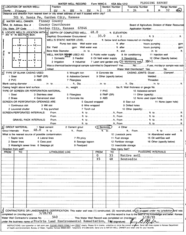
Specific Water Well Detail |
|
|
| Location Info | |||
| Owner: Finney County | Status: Plugged | ||
| Location: T24S, R32W, Sec. 18, SW NW SW | County: Finney | ||
| Directions: 501 W Santa Fe, Garden City | |||
| Latitude: 37.9650267 | Longitude: -100.8817938 | Datum NAD 27 | |
| Latitude: 37.9650499 | Longitude: -100.8822338 | Datum NAD 83 | |
| Longitude and latitude calculated by Survey from township-range-section-quarter calls. Only good to within the quarter call accuracy. | |||
| View well on interactive map | |||
| General Info | ||
| Well Depth: 48 ft. | Elevation: ft. | |
| Static Water Level: ft. | Est. Yield: gpm. | |
| Comp. Date: 28-May-1993 | Well Use: Monitoring well/observation/piezometer | |
| DWR Applic. #: | Other ID: MW 1 | |
| Driller Info | ||
| Driller: Prairie Land Environmental Remed. | License #: 540 | |
| Scanned Form | View scan |
| Casing Info | ||
|
Casing Type: PVC
Diam: 2 in. Casing height above land surface: in | ||
| Grout Info | ||
| Grout used: Bentonite | From: 0 to 48 ft
From: 0 to 0 ft From: 0 to 0 ft | |
| Source of Possible Contamination | ||
| Source: OTHER | ||
| Direction from well: | Distance: 0 ft | |