|
|
|
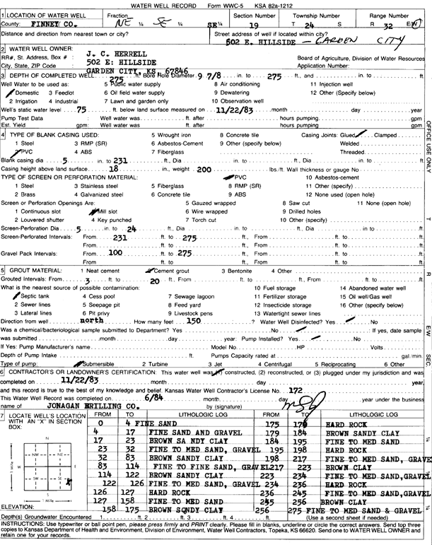
Specific Water Well Detail |
|
|
| Location Info | |||
| Owner: Herrell, J.C. | Status: Constructed | ||
| Location: T24S, R32W, Sec. 19, NE SE SE | County: Finney | ||
| Directions: 502 E Hillside, Garden City | |||
| Latitude: 37.9487335 | Longitude: -100.866091 | Datum NAD 27 | |
| Latitude: 37.9487567 | Longitude: -100.8665306 | Datum NAD 83 | |
| Longitude and latitude calculated by Survey from township-range-section-quarter calls. Only good to within the quarter call accuracy. | |||
| View well on interactive map | |||
| General Info | ||
| Well Depth: 275 ft. | Elevation: ft. | |
| Static Water Level: 75 ft. | Est. Yield: gpm. | |
| Comp. Date: 22-Nov-1983 | Well Use: Domestic | |
| DWR Applic. #: | Other ID: | |
| Driller Info | ||
| Driller: Jonagan Water Well Service LLC | License #: 172 | |
| Scanned Form | View scan |
|
Chemical Sample Submitted?: No
Water Well disinfected?: | ||
| Ground water encountered: 0 ft. , 0 ft. , 0 ft. | ||
| Pump test data: Well water was 0 ft after 0 hours pumping 0 gpm | ||
| Casing Info | ||
| Casing Type: PVC
Casing Joints: |
Diam: 5 in. to 231 ft
Diam: 0 in. to 0 ft Diam: 0 in. to 0 ft | |
| Casing height above land surface: in
Casing Weight: lbs/ft Wall thickness or gauge no.: | ||
| Screen and Perforation Info | ||
| Screen Type: PVC | Screen Openings: Mill slot | |
| Screen-perforated intervals | From: 231 ft to 275 ft
From: 0 ft to 0 ft From: 0 ft to 0 ft | |
| Gravel pack intervals | From: ft to ft | |
| Grout Info | ||
| Grout used: Cement grout | From: 3 to 20 ft
From: 0 to 0 ft From: 0 to 0 ft | |
| Source of Possible Contamination | ||
| Source: Septic Tank | ||
| Direction from well: | Distance: 0 ft | |
| Lithologic Log
(Log data entered by KGS.) | ||
| From: 0 ft. to 4 ft. | fine sand | |
| From: 4 ft. to 17 ft. | fine sand and gravel | |
| From: 17 ft. to 23 ft. | brown sandy clay | |
| From: 23 ft. to 32 ft. | fine to medium sand, gravel | |
| From: 32 ft. to 83 ft. | brown sandy clay | |
| From: 83 ft. to 114 ft. | fine to fine sand, gravel | |
| From: 114 ft. to 122 ft. | brown sandy clay | |
| From: 122 ft. to 126 ft. | fine to medium sand, gravel | |
| From: 126 ft. to 127 ft. | hard rock | |
| From: 127 ft. to 158 ft. | fine to medium sand | |
| From: 158 ft. to 175 ft. | brown sandy clay | |
| From: 175 ft. to 179 ft. | hard rock | |
| From: 179 ft. to 184 ft. | brown sandy clay | |
| From: 184 ft. to 195 ft. | fine to medium sand | |
| From: 195 ft. to 198 ft. | hard rock | |
| From: 198 ft. to 217 ft. | fine to medium sand, gravel | |
| From: 217 ft. to 223 ft. | brown clay | |
| From: 223 ft. to 234 ft. | fine to medium sand, gravel | |
| From: 234 ft. to 236 ft. | hard rock | |
| From: 236 ft. to 245 ft. | fine to medium sand, gravel | |
| From: 245 ft. to 256 ft. | brown clay | |
| From: 256 ft. to 275 ft. | fine to medium sand and gravel | |