|
|
|
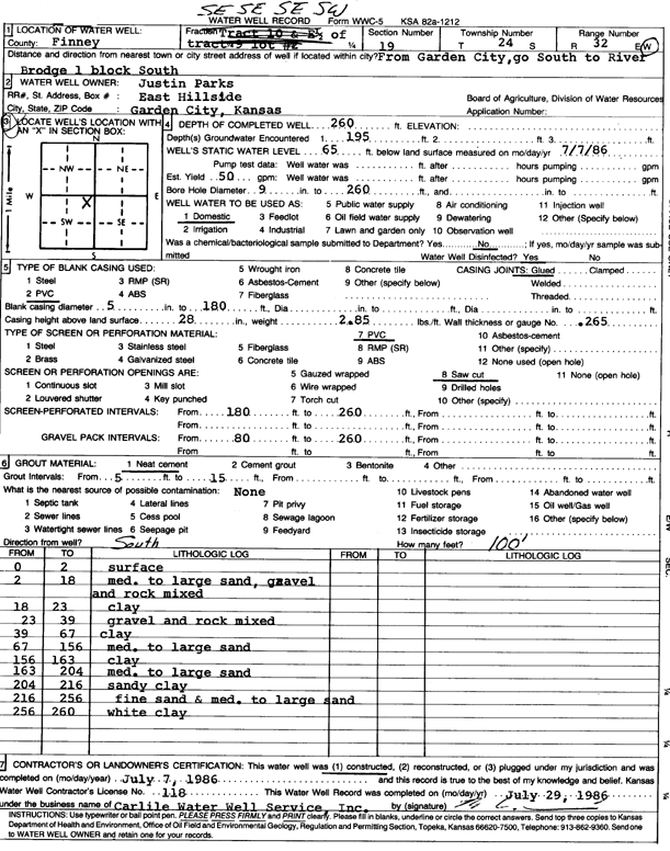
Specific Water Well Detail |
|
|
| Location Info | |||
| Owner: Parks, Justin | Status: Constructed | ||
| Location: T24S, R32W, Sec. 19, SE SE SW | County: Finney | ||
| Directions: from Garden City, S to River Bridge, 1 block S | |||
| Latitude: 37.9468698 | Longitude: -100.8750978 | Datum NAD 27 | |
| Latitude: 37.9468931 | Longitude: -100.8755378 | Datum NAD 83 | |
| Longitude and latitude calculated by Survey from township-range-section-quarter calls. Only good to within the quarter call accuracy. | |||
| View well on interactive map | |||
| General Info | ||
| Well Depth: 260 ft. | Elevation: ft. | |
| Static Water Level: 65 ft. | Est. Yield: 50 gpm. | |
| Comp. Date: 07-Jul-1986 | Well Use: Domestic | |
| DWR Applic. #: | Other ID: | |
| Driller Info | ||
| Driller: Bernard E. Carlile Water Well Service, Inc. | License #: 118 | |
| Scanned Form | View scan |
|
Chemical Sample Submitted?: No
Water Well disinfected?: | ||
| Ground water encountered: 195 ft. , 0 ft. , 0 ft. | ||
| Pump test data: Well water was 0 ft after 0 hours pumping 0 gpm | ||
| Casing Info | ||
| Casing Type: PVC
Casing Joints: |
Diam: 5 in. to 180 ft
Diam: 0 in. to 0 ft Diam: 0 in. to 0 ft | |
| Casing height above land surface: in
Casing Weight: lbs/ft Wall thickness or gauge no.: | ||
| Screen and Perforation Info | ||
| Screen Type: PVC | Screen Openings: Saw cut | |
| Screen-perforated intervals | From: 180 ft to 260 ft
From: 0 ft to 0 ft From: 0 ft to 0 ft | |
| Gravel pack intervals | From: ft to ft | |
| Grout Info | ||
| Grout used: Neat cement | From: 5 to 15 ft
From: 0 to 0 ft From: 0 to 0 ft | |
| Source of Possible Contamination | ||
| Source: | ||
| Direction from well: | Distance: 0 ft | |
| Lithologic Log
(Log data entered by KGS.) | ||
| From: 0 ft. to 2 ft. | surface | |
| From: 2 ft. to 18 ft. | medium to large sand, gravel and rock mixed | |
| From: 18 ft. to 23 ft. | clay | |
| From: 23 ft. to 39 ft. | gravel and rock mixed | |
| From: 39 ft. to 67 ft. | clay | |
| From: 67 ft. to 156 ft. | medium to large sand | |
| From: 156 ft. to 163 ft. | clay | |
| From: 163 ft. to 204 ft. | medium to large sand | |
| From: 204 ft. to 216 ft. | sandy clay | |
| From: 216 ft. to 256 ft. | fine sand and medium to large sand | |
| From: 256 ft. to 260 ft. | white clay | |