|
|
|
Specific Water Well Detail |
|
|
| Location Info | |||
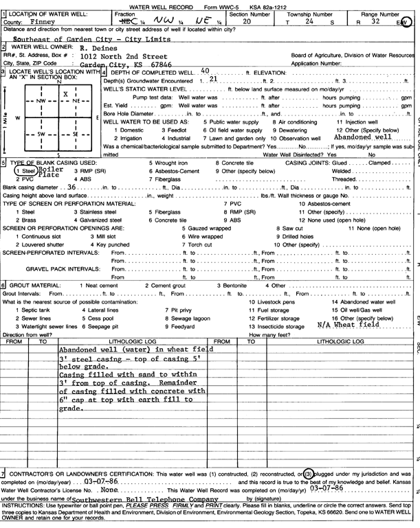
| Owner: Deines, R. | Status: Plugged | ||
| Location: T24S, R32W, Sec. 20, C NW NE | County: Finney | ||
| Directions: SE of Garden City city limits | |||
| Latitude: 37.9586759 | Longitude: -100.8535656 | Datum NAD 27 | |
| Latitude: 37.958699 | Longitude: -100.8540047 | Datum NAD 83 | |
| Longitude and latitude calculated by Survey from township-range-section-quarter calls. Only good to within the quarter call accuracy. | |||
| View well on interactive map | |||
| General Info | ||
| Well Depth: 40 ft. | Elevation: ft. | |
| Static Water Level: ft. | Est. Yield: gpm. | |
| Comp. Date: 07-Mar-1986 | Well Use: (unstated)/abandoned | |
| DWR Applic. #: | Other ID: | |
| Links | |
| View info from Wizard Water Level Data base... | |
| No WIMAS information available. | |
| Driller Info | ||
| Driller: Southwestern Bell Telephone Co | License #: | |
| Scanned Form | View scan |
| Casing Info | ||
|
Casing Type: Steel
Diam: 36 in. Casing height above land surface: in | ||
| Grout Info | ||
| Grout used: | From: 0 to 0 ft
From: 0 to 0 ft From: 0 to 0 ft | |
| Source of Possible Contamination | ||
| Source: | ||
| Direction from well: | Distance: 0 ft | |