|
|
|
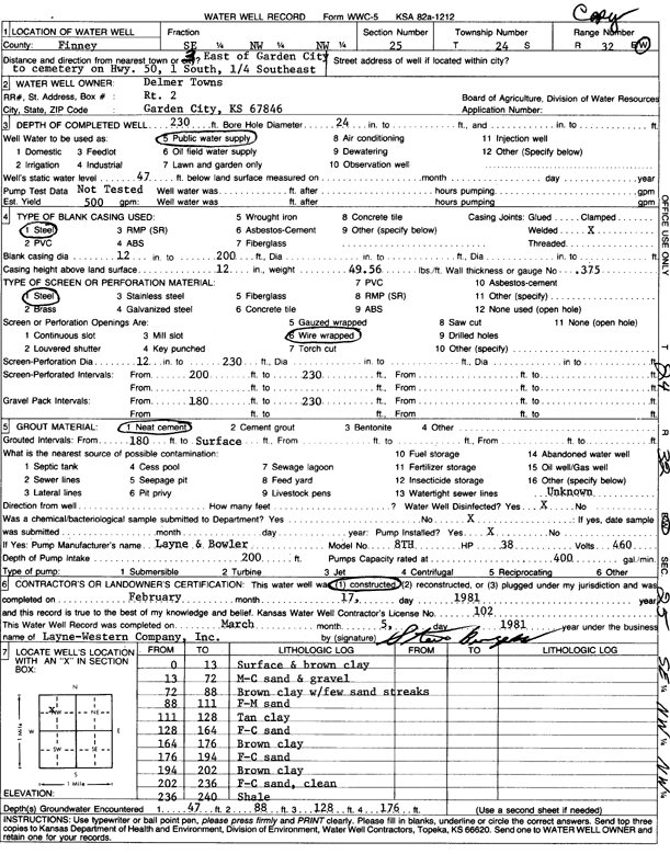
Specific Water Well Detail |
|
|
| Location Info | |||
| Owner: Towns, Delmer | Status: Constructed | ||
| Location: T24S, R32W, Sec. 25, SE NW NW | County: Finney | ||
| Directions: 3 E on HWY 50 to cemetery, 1 S, .25 SE | |||
| Latitude: 37.9429948 | Longitude: -100.7886039 | Datum NAD 27 | |
| Latitude: 37.9430173 | Longitude: -100.7890405 | Datum NAD 83 | |
| Longitude and latitude calculated by Survey from township-range-section-quarter calls. Only good to within the quarter call accuracy. | |||
| View well on interactive map | |||
| General Info | ||
| Well Depth: 230 ft. | Elevation: ft. | |
| Static Water Level: 47 ft. | Est. Yield: 500 gpm. | |
| Comp. Date: 17-Feb-1981 | Well Use: Public Water Supply | |
| DWR Applic. #: | Other ID: | |
| Links | |
| No Wizard information available. | |
| View info from WIMAS Water Right Data base... | |
| Driller Info | ||
| Driller: Layne-Christensen Co. | License #: 102 | |
| Scanned Form | View scan |
|
Chemical Sample Submitted?: No
Water Well disinfected?: | ||
| Ground water encountered: 0 ft. , 0 ft. , 0 ft. | ||
| Pump test data: Well water was 0 ft after 0 hours pumping 0 gpm | ||
| Casing Info | ||
| Casing Type:
Casing Joints: |
Diam: 0 in. to 0 ft
Diam: 0 in. to 0 ft Diam: 0 in. to 0 ft | |
| Casing height above land surface: in
Casing Weight: lbs/ft Wall thickness or gauge no.: | ||
| Screen and Perforation Info | ||
| Screen Type: | Screen Openings: | |
| Screen-perforated intervals | From: 200 ft to 230 ft
From: 0 ft to 0 ft From: 0 ft to 0 ft | |
| Gravel pack intervals | From: ft to ft | |
| Grout Info | ||
| Grout used: | From: 0 to 0 ft
From: 0 to 0 ft From: 0 to 0 ft | |
| Source of Possible Contamination | ||
| Source: | ||
| Direction from well: | Distance: 0 ft | |
| Lithologic Log
(Log data entered by KGS.) | ||
| From: 0 ft. to 13 ft. | surface and brown clay | |
| From: 13 ft. to 72 ft. | m-c sand and gravel | |
| From: 72 ft. to 88 ft. | brown clay with few sand streaks | |
| From: 88 ft. to 111 ft. | f-m sand | |
| From: 111 ft. to 128 ft. | tan clay | |
| From: 128 ft. to 164 ft. | f-c sand | |
| From: 164 ft. to 176 ft. | brown clay | |
| From: 176 ft. to 194 ft. | f-c sand | |
| From: 194 ft. to 202 ft. | brown clay | |
| From: 202 ft. to 236 ft. | f-c sand, clean | |
| From: 236 ft. to 240 ft. | shale | |