|
|
|
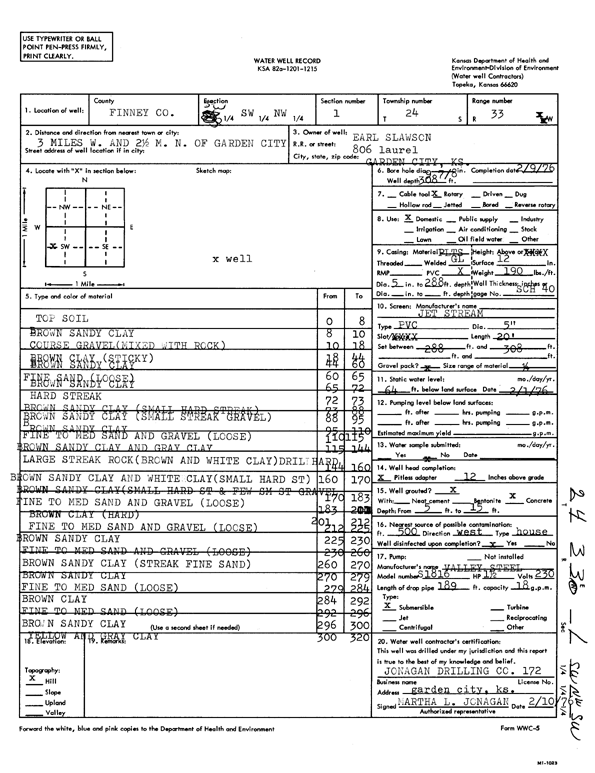
Specific Water Well Detail |
|
|
| Location Info | |||
| Owner: Slawson, Earl | Status: Constructed | ||
| Location: T24S, R33W, Sec. 1, SW SW NW | County: Finney | ||
| Directions: from Garden City, 3 mi W and 2.5 mi N | |||
| Latitude: 37.9976168 | Longitude: -100.9002107 | Datum NAD 27 | |
| Latitude: 37.9976401 | Longitude: -100.9006512 | Datum NAD 83 | |
| Longitude and latitude calculated by Survey from township-range-section-quarter calls. Only good to within the quarter call accuracy. | |||
| View well on interactive map | |||
| General Info | ||
| Well Depth: 308 ft. | Elevation: ft. | |
| Static Water Level: 64 ft. | Est. Yield: gpm. | |
| Comp. Date: 09-Feb-1976 | Well Use: Domestic | |
| DWR Applic. #: | Other ID: | |
| Driller Info | ||
| Driller: Jonagan Drilling Co. | License #: 172 | |
| Scanned Form | View scan |
|
Chemical Sample Submitted?: No
Water Well disinfected?: | ||
| Ground water encountered: 0 ft. , 0 ft. , 0 ft. | ||
| Pump test data: Well water was 0 ft after 0 hours pumping 0 gpm | ||
| Casing Info | ||
| Casing Type:
Casing Joints: |
Diam: 0 in. to 0 ft
Diam: 0 in. to 0 ft Diam: 0 in. to 0 ft | |
| Casing height above land surface: in
Casing Weight: lbs/ft Wall thickness or gauge no.: | ||
| Screen and Perforation Info | ||
| Screen Type: | Screen Openings: | |
| Screen-perforated intervals | From: 288 ft to 308 ft
From: 0 ft to 0 ft From: 0 ft to 0 ft | |
| Gravel pack intervals | From: ft to ft | |
| Grout Info | ||
| Grout used: | From: 0 to 0 ft
From: 0 to 0 ft From: 0 to 0 ft | |
| Source of Possible Contamination | ||
| Source: | ||
| Direction from well: | Distance: 0 ft | |
| Lithologic Log
(Log data entered by KGS.) | ||
| From: 0 ft. to 8 ft. | top soil | |
| From: 8 ft. to 10 ft. | brown sandy clay | |
| From: 10 ft. to 18 ft. | coarse gravel (mixed with rock) | |
| From: 18 ft. to 44 ft. | brown clay (sticky) | |
| From: 44 ft. to 60 ft. | brown sandy clay | |
| From: 60 ft. to 65 ft. | fine sand (loose) | |
| From: 65 ft. to 72 ft. | brown sandy clay | |
| From: 72 ft. to 73 ft. | hard streak | |
| From: 73 ft. to 88 ft. | brown sandy clay (small hard streak) | |
| From: 88 ft. to 95 ft. | brown sandy clay (small streak gravel) | |
| From: 95 ft. to 110 ft. | brown sandy clay | |
| From: 110 ft. to 115 ft. | fine to medium sand and gravel (loose) | |
| From: 115 ft. to 144 ft. | brown sandy clay and gray clay | |
| From: 144 ft. to 160 ft. | large streak rock (brown and white clay) drill hard | |
| From: 160 ft. to 170 ft. | brown sandy clay and white clay (small hard st) | |
| From: 170 ft. to 183 ft. | brown sandy clay (small hard st and few sm st gravel) | |
| From: 183 ft. to 201 ft. | fine to medium sand and gravel (loose) | |
| From: 201 ft. to 212 ft. | brown clay (hard) | |
| From: 212 ft. to 225 ft. | fine to medium sand and gravel (loose) | |
| From: 225 ft. to 230 ft. | brown sandy clay | |
| From: 230 ft. to 260 ft. | fine to medium sand and gravel (loose) | |
| From: 260 ft. to 270 ft. | brown sandy clay (streak fine sand) | |
| From: 270 ft. to 279 ft. | brown sandy clay | |
| From: 279 ft. to 284 ft. | fine to medium sand (loose) | |
| From: 284 ft. to 292 ft. | brown clay | |
| From: 292 ft. to 296 ft. | fine to medium sand (loose) | |
| From: 296 ft. to 300 ft. | brown sandy clay | |
| From: 300 ft. to 320 ft. | yellow and gray clay | |