|
|
|
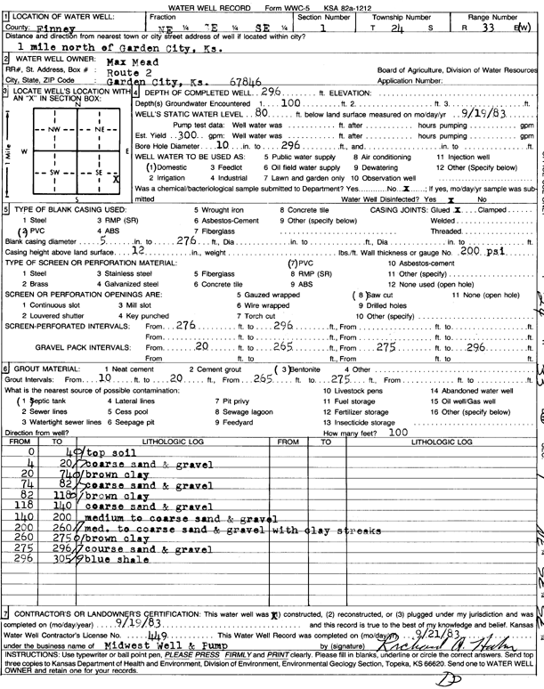
Specific Water Well Detail |
|
|
| Location Info | |||
| Owner: Mead, Max | Status: Constructed | ||
| Location: T24S, R33W, Sec. 1, NE SE SE | County: Finney | ||
| Directions: from Garden City, 1 mi N | |||
| Latitude: 37.9922248 | Longitude: -100.8841144 | Datum NAD 27 | |
| Latitude: 37.9922479 | Longitude: -100.8845543 | Datum NAD 83 | |
| Longitude and latitude calculated by Survey from township-range-section-quarter calls. Only good to within the quarter call accuracy. | |||
| View well on interactive map | |||
| General Info | ||
| Well Depth: 296 ft. | Elevation: ft. | |
| Static Water Level: 80 ft. | Est. Yield: 300 gpm. | |
| Comp. Date: 19-Sep-1983 | Well Use: Domestic | |
| DWR Applic. #: | Other ID: | |
| Driller Info | ||
| Driller: Midwest Well & Pump | License #: 449 | |
| Scanned Form | View scan |
|
Chemical Sample Submitted?: No
Water Well disinfected?: | ||
| Ground water encountered: 0 ft. , 0 ft. , 0 ft. | ||
| Pump test data: Well water was 0 ft after 0 hours pumping 0 gpm | ||
| Casing Info | ||
| Casing Type:
Casing Joints: |
Diam: 0 in. to 0 ft
Diam: 0 in. to 0 ft Diam: 0 in. to 0 ft | |
| Casing height above land surface: in
Casing Weight: lbs/ft Wall thickness or gauge no.: | ||
| Screen and Perforation Info | ||
| Screen Type: | Screen Openings: | |
| Screen-perforated intervals | From: 276 ft to 296 ft
From: 0 ft to 0 ft From: 0 ft to 0 ft | |
| Gravel pack intervals | From: ft to ft | |
| Grout Info | ||
| Grout used: | From: 0 to 0 ft
From: 0 to 0 ft From: 0 to 0 ft | |
| Source of Possible Contamination | ||
| Source: | ||
| Direction from well: | Distance: 0 ft | |
| Lithologic Log
(Log data entered by KGS.) | ||
| From: 0 ft. to 4 ft. | top soil | |
| From: 4 ft. to 20 ft. | coarse sand and gravel | |
| From: 20 ft. to 74 ft. | brown clay | |
| From: 74 ft. to 82 ft. | coarse sand and gravel | |
| From: 82 ft. to 118 ft. | brown clay | |
| From: 118 ft. to 140 ft. | coarse sand and gravel | |
| From: 140 ft. to 200 ft. | medium to coarse sand and gravel | |
| From: 200 ft. to 260 ft. | med. to coarse sand and gravel with clay streaks | |
| From: 260 ft. to 275 ft. | brown clay | |
| From: 275 ft. to 296 ft. | coarse sand and gravel | |
| From: 296 ft. to 305 ft. | blue shale | |