|
|
|
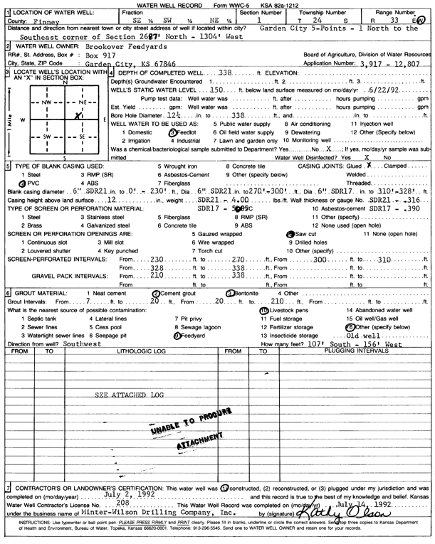
Specific Water Well Detail |
|
|
| Location Info | |||
| Owner: Brookover Feed Yard | Status: Constructed | ||
| Location: T24S, R33W, Sec. 1, SE SW NE | County: Finney | ||
| Directions: from 5 Points: 1 mi N to SE corner of section 26, 87 feet N and 1304 feet W | |||
| Latitude: 37.9976417 | Longitude: -100.8887136 | Datum NAD 27 | |
| Latitude: 37.9976649 | Longitude: -100.8891536 | Datum NAD 83 | |
| Longitude and latitude calculated by Survey from township-range-section-quarter calls. Only good to within the quarter call accuracy. | |||
| View well on interactive map | |||
| General Info | ||
| Well Depth: 338 ft. | Elevation: ft. | |
| Static Water Level: 150 ft. | Est. Yield: gpm. | |
| Comp. Date: 02-Jul-1992 | Well Use: Feedlot | |
| DWR Applic. #: 3917 | Other ID: | |
| Links | |
| No Wizard information available. | |
| View info from WIMAS Water Right Data base... | |
| Driller Info | ||
| Driller: Minter-Wilson Drlg. Co., Inc. | License #: 208 | |
| Scanned Form | View scan |
|
Chemical Sample Submitted?: No
Water Well disinfected?: | ||
| Ground water encountered: 0 ft. , 0 ft. , 0 ft. | ||
| Pump test data: Well water was 0 ft after 0 hours pumping 0 gpm | ||
| Casing Info | ||
| Casing Type: PVC
Casing Joints: |
Diam: 6 in. to 230 ft
Diam: 6 in. to 300 ft Diam: 6 in. to 328 ft | |
| Casing height above land surface: in
Casing Weight: lbs/ft Wall thickness or gauge no.: | ||
| Screen and Perforation Info | ||
| Screen Type: PVC | Screen Openings: Saw cut | |
| Screen-perforated intervals | From: 230 ft to 270 ft
From: 300 ft to 310 ft From: 328 ft to 338 ft | |
| Gravel pack intervals | From: ft to ft | |
| Grout Info | ||
| Grout used: Cement grout, Bentonite | From: 7 to 20 ft
From: 20 to 210 ft From: 0 to 0 ft | |
| Source of Possible Contamination | ||
| Source: Feedyard | ||
| Direction from well: | Distance: 0 ft | |
| Lithologic Log
(log data not edited or checked by the KGS.) | ||
| From: 0 ft. to 15 ft. | Type: CLAY | |
| From: 15 ft. to 39 ft. | Type: FINE SAND | |
| From: 39 ft. to 47 ft. | Type: CLAY & GRAVEL | |
| From: 47 ft. to 67 ft. | Type: CLAY | |
| From: 67 ft. to 105 ft. | Type: ROCK & CLAY | |
| From: 105 ft. to 120 ft. | Type: CLAY & GRAVEL | |
| From: 120 ft. to 149 ft. | Type: CLAY | |
| From: 149 ft. to 154 ft. | Type: SANDY CLAY | |
| From: 154 ft. to 200 ft. | Type: CLAY & GRAVEL | |
| From: 200 ft. to 266 ft. | Type: SAND & GRAVEL | |
| From: 266 ft. to 307 ft. | Type: CLAY | |
| From: 307 ft. to 309 ft. | Type: SAND & GRAVEL | |
| From: 309 ft. to 330 ft. | Type: CLAY | |
| From: 330 ft. to 337 ft. | Type: FINE GRAVEL | |
| From: 337 ft. to 339 ft. | Type: SHALE | |