|
|
|
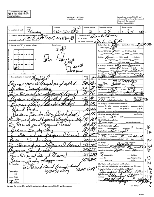
Specific Water Well Detail |
|
|
| Location Info | |||
| Owner: Morris, Frank | Status: Constructed | ||
| Location: T24S, R33W, Sec. 2, SW SW SW | County: Finney | ||
| Directions: 1 mi N VFW Rd., 1 mi E on Mary St | |||
| Latitude: 37.9903867 | Longitude: -100.9185494 | Datum NAD 27 | |
| Latitude: 37.9904102 | Longitude: -100.9189907 | Datum NAD 83 | |
| Longitude and latitude calculated by Survey from township-range-section-quarter calls. Only good to within the quarter call accuracy. | |||
| View well on interactive map | |||
| General Info | ||
| Well Depth: 298 ft. | Elevation: ft. | |
| Static Water Level: 101 ft. | Est. Yield: gpm. | |
| Comp. Date: 29-Jul-1976 | Well Use: Domestic | |
| DWR Applic. #: | Other ID: | |
| Driller Info | ||
| Driller: Jonagan Drilling Co. | License #: 172 | |
| Scanned Form | View scan |
|
Chemical Sample Submitted?: No
Water Well disinfected?: | ||
| Ground water encountered: 0 ft. , 0 ft. , 0 ft. | ||
| Pump test data: Well water was 0 ft after 0 hours pumping 0 gpm | ||
| Casing Info | ||
| Casing Type:
Casing Joints: |
Diam: 0 in. to 0 ft
Diam: 0 in. to 0 ft Diam: 0 in. to 0 ft | |
| Casing height above land surface: in
Casing Weight: lbs/ft Wall thickness or gauge no.: | ||
| Screen and Perforation Info | ||
| Screen Type: | Screen Openings: | |
| Screen-perforated intervals | From: 263 ft to 283 ft
From: 288 ft to 298 ft From: 0 ft to 0 ft | |
| Gravel pack intervals | From: ft to ft | |
| Grout Info | ||
| Grout used: | From: 0 to 0 ft
From: 0 to 0 ft From: 0 to 0 ft | |
| Source of Possible Contamination | ||
| Source: | ||
| Direction from well: | Distance: 0 ft | |
| Lithologic Log
(Log data entered by KGS.) | ||
| From: 0 ft. to 5 ft. | topsoil | |
| From: 5 ft. to 22 ft. | coarse gravel (loose) mixed with rock | |
| From: 22 ft. to 38 ft. | brown sandy clay | |
| From: 38 ft. to 76 ft. | fine to medium sand and gravel (loose) | |
| From: 76 ft. to 80 ft. | brown clay (drilled hard) | |
| From: 80 ft. to 110 ft. | brown clay (hard and sticky) | |
| From: 110 ft. to 112 ft. | hard rock | |
| From: 112 ft. to 141 ft. | brown sandy clay (sm hd st) | |
| From: 141 ft. to 160 ft. | fine to medium sand and gravel (loose) with sm st clay | |
| From: 160 ft. to 187 ft. | fine to medium sand and gravel (loose) | |
| From: 187 ft. to 189 ft. | brown sandy clay | |
| From: 189 ft. to 225 ft. | fine to medium sand and gravel (loose) | |
| From: 225 ft. to 233 ft. | brown sandy clay | |
| From: 233 ft. to 240 ft. | fine to medium sand and gravel (loose) | |
| From: 240 ft. to 255 ft. | brown sandy clay | |
| From: 255 ft. to 270 ft. | fine to medium sand (loose) | |
| From: 270 ft. to 280 ft. | brown sandy clay | |
| From: 280 ft. to 298 ft. | fine to medium sand (loose) mixed with 20% clay | |