|
|
|
Specific Water Well Detail |
|
|
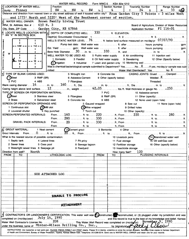
| Location Info | |||
| Owner: Brown Family Living Trust | Status: Constructed | ||
| Location: T24S, R33W, Sec. 4, SW NW SW | County: Finney | ||
| Directions: from 5 Points: 3 mi W, 1775 feet N, 5220 feet W of the SE corner of section | |||
| Latitude: 37.9936053 | Longitude: -100.9554816 | Datum NAD 27 | |
| Latitude: 37.9936292 | Longitude: -100.9559244 | Datum NAD 83 | |
| Longitude and latitude calculated by Survey from township-range-section-quarter calls. Only good to within the quarter call accuracy. | |||
| View well on interactive map | |||
| General Info | ||
| Well Depth: 330 ft. | Elevation: ft. | |
| Static Water Level: 76 ft. | Est. Yield: gpm. | |
| Comp. Date: 14-Jul-1990 | Well Use: Irrigation | |
| DWR Applic. #: FI 166-D1 | Other ID: | |
| Links | |
| No Wizard information available. | |
| View info from WIMAS Water Right Data base... | |
| Driller Info | ||
| Driller: MW Drilling | License #: 208 | |
| Scanned Form | View scan |
|
Chemical Sample Submitted?: No
Water Well disinfected?: | ||
| Ground water encountered: 0 ft. , 0 ft. , 0 ft. | ||
| Pump test data: Well water was 0 ft after 0 hours pumping 0 gpm | ||
| Casing Info | ||
| Casing Type: Steel
Casing Joints: |
Diam: 16 in. to 160 ft
Diam: 0 in. to 0 ft Diam: 0 in. to 0 ft | |
| Casing height above land surface: in
Casing Weight: lbs/ft Wall thickness or gauge no.: | ||
| Screen and Perforation Info | ||
| Screen Type: Steel | Screen Openings: Wire wrapped | |
| Screen-perforated intervals | From: 160 ft to 220 ft
From: 220 ft to 280 ft From: 280 ft to 330 ft | |
| Gravel pack intervals | From: ft to ft | |
| Grout Info | ||
| Grout used: Cement grout | From: 0 to 20 ft
From: 0 to 0 ft From: 0 to 0 ft | |
| Source of Possible Contamination | ||
| Source: Abandoned water well | ||
| Direction from well: | Distance: 0 ft | |
| Lithologic Log
(log data not edited or checked by the KGS.) | ||
| From: 0 ft. to 7 ft. | Type: CLAY | |
| From: 7 ft. to 25 ft. | Type: GRAVEL | |
| From: 25 ft. to 40 ft. | Type: CLAY | |
| From: 40 ft. to 62 ft. | Type: SANDY CLAY | |
| From: 62 ft. to 94 ft. | Type: FINE SAND | |
| From: 94 ft. to 122 ft. | Type: SAND | |
| From: 122 ft. to 145 ft. | Type: SANDY CLAY | |
| From: 145 ft. to 156 ft. | Type: SHALE & LIMESTONE | |
| From: 156 ft. to 164 ft. | Type: GRAVEL | |
| From: 164 ft. to 190 ft. | Type: SAND | |
| From: 190 ft. to 207 ft. | Type: GRAVEL | |
| From: 207 ft. to 208 ft. | Type: SANDSTONE | |
| From: 208 ft. to 220 ft. | Type: COARSE GRAVEL | |
| From: 220 ft. to 237 ft. | Type: SAND | |
| From: 237 ft. to 242 ft. | Type: SANDY CLAY | |
| From: 242 ft. to 245 ft. | Type: SAND | |
| From: 245 ft. to 259 ft. | Type: GRAVEL | |
| From: 259 ft. to 264 ft. | Type: CLAY | |
| From: 264 ft. to 279 ft. | Type: GRAVEL | |
| From: 279 ft. to 310 ft. | Type: SANDY CLAY | |
| From: 310 ft. to 316 ft. | Type: COARSE GRAVEL | |
| From: 316 ft. to 317 ft. | Type: SANDSTONE | |
| From: 317 ft. to 330 ft. | Type: SANDY CLAY | |
| From: 330 ft. to 335 ft. | Type: SHALE | |