|
|
|
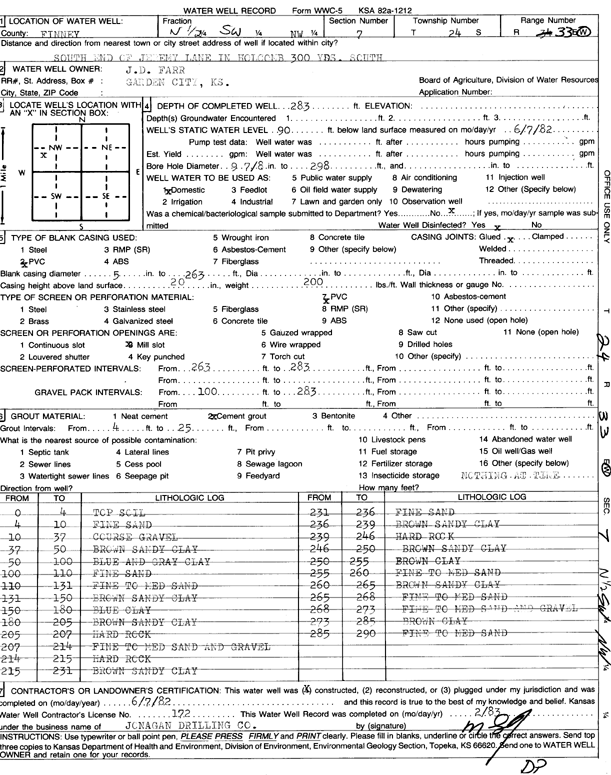
Specific Water Well Detail |
|
|
| Location Info | |||
| Owner: Farr, J.D. | Status: Constructed | ||
| Location: T24S, R33W, Sec. 7, N2 SW NW | County: Finney | ||
| Directions: S end of Jeremy Ln, 900' S | |||
| Latitude: 37.984583 | Longitude: -100.9904544 | Datum NAD 27 | |
| Latitude: 37.9846073 | Longitude: -100.9908986 | Datum NAD 83 | |
| Longitude and latitude calculated by Survey from township-range-section-quarter calls. Only good to within the quarter call accuracy. | |||
| View well on interactive map | |||
| General Info | ||
| Well Depth: 283 ft. | Elevation: ft. | |
| Static Water Level: 90 ft. | Est. Yield: gpm. | |
| Comp. Date: 07-Jun-1982 | Well Use: Domestic | |
| DWR Applic. #: | Other ID: | |
| Driller Info | ||
| Driller: Jonagan Water Well Service LLC | License #: 172 | |
| Scanned Form | View scan |
|
Chemical Sample Submitted?: No
Water Well disinfected?: | ||
| Ground water encountered: 0 ft. , 0 ft. , 0 ft. | ||
| Pump test data: Well water was 0 ft after 0 hours pumping 0 gpm | ||
| Casing Info | ||
| Casing Type:
Casing Joints: |
Diam: 0 in. to 0 ft
Diam: 0 in. to 0 ft Diam: 0 in. to 0 ft | |
| Casing height above land surface: in
Casing Weight: lbs/ft Wall thickness or gauge no.: | ||
| Screen and Perforation Info | ||
| Screen Type: | Screen Openings: | |
| Screen-perforated intervals | From: 263 ft to 283 ft
From: 0 ft to 0 ft From: 0 ft to 0 ft | |
| Gravel pack intervals | From: ft to ft | |
| Grout Info | ||
| Grout used: | From: 0 to 0 ft
From: 0 to 0 ft From: 0 to 0 ft | |
| Source of Possible Contamination | ||
| Source: | ||
| Direction from well: | Distance: 0 ft | |
| Lithologic Log
(Log data entered by KGS.) | ||
| From: 0 ft. to 4 ft. | top soil | |
| From: 4 ft. to 10 ft. | fine sand | |
| From: 10 ft. to 37 ft. | coarse gravel | |
| From: 37 ft. to 50 ft. | brown sandy clay | |
| From: 50 ft. to 100 ft. | blue and gray clay | |
| From: 100 ft. to 110 ft. | fine sand | |
| From: 110 ft. to 131 ft. | fine to medium sand | |
| From: 131 ft. to 150 ft. | brown sandy clay | |
| From: 150 ft. to 180 ft. | blue clay | |
| From: 180 ft. to 205 ft. | brown sandy clay | |
| From: 205 ft. to 207 ft. | hard rock | |
| From: 207 ft. to 214 ft. | fine to medium sand and gravel | |
| From: 214 ft. to 215 ft. | hard rock | |
| From: 215 ft. to 231 ft. | brown sandy clay | |
| From: 231 ft. to 236 ft. | fine sand | |
| From: 236 ft. to 239 ft. | brown sandy clay | |
| From: 239 ft. to 246 ft. | hard rock | |
| From: 246 ft. to 250 ft. | brown sandy clay | |
| From: 250 ft. to 255 ft. | brown clay | |
| From: 255 ft. to 260 ft. | fine to medium sand | |
| From: 260 ft. to 265 ft. | brown sandy clay | |
| From: 265 ft. to 268 ft. | fine to medium sand | |
| From: 268 ft. to 273 ft. | fine to medium sand and gravel | |
| From: 273 ft. to 285 ft. | brown clay | |
| From: 285 ft. to 290 ft. | fine to medium sand | |