|
|
|
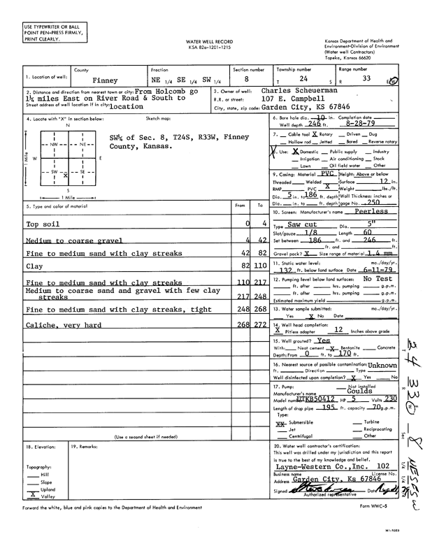
Specific Water Well Detail |
|
|
| Location Info | |||
| Owner: Scheuerman, Charles | Status: Constructed | ||
| Location: T24S, R33W, Sec. 8, NE SE SW | County: Finney | ||
| Directions: from Holcomb: 1.25 mi E on River Rd, S to location | |||
| Latitude: 37.9772243 | Longitude: -100.9666992 | Datum NAD 27 | |
| Latitude: 37.9772483 | Longitude: -100.9671426 | Datum NAD 83 | |
| Longitude and latitude calculated by Survey from township-range-section-quarter calls. Only good to within the quarter call accuracy. | |||
| View well on interactive map | |||
| General Info | ||
| Well Depth: 246 ft. | Elevation: ft. | |
| Static Water Level: 132 ft. | Est. Yield: gpm. | |
| Comp. Date: 28-Aug-1979 | Well Use: Domestic | |
| DWR Applic. #: | Other ID: | |
| Driller Info | ||
| Driller: Layne-Christensen Co. | License #: 102 | |
| Scanned Form | View scan |
|
Chemical Sample Submitted?: No
Water Well disinfected?: | ||
| Ground water encountered: 0 ft. , 0 ft. , 0 ft. | ||
| Pump test data: Well water was 0 ft after 0 hours pumping 0 gpm | ||
| Casing Info | ||
| Casing Type:
Casing Joints: |
Diam: 0 in. to 0 ft
Diam: 0 in. to 0 ft Diam: 0 in. to 0 ft | |
| Casing height above land surface: in
Casing Weight: lbs/ft Wall thickness or gauge no.: | ||
| Screen and Perforation Info | ||
| Screen Type: | Screen Openings: | |
| Screen-perforated intervals | From: 186 ft to 246 ft
From: 0 ft to 0 ft From: 0 ft to 0 ft | |
| Gravel pack intervals | From: ft to ft | |
| Grout Info | ||
| Grout used: | From: 0 to 0 ft
From: 0 to 0 ft From: 0 to 0 ft | |
| Source of Possible Contamination | ||
| Source: | ||
| Direction from well: | Distance: 0 ft | |
| Lithologic Log
(Log data entered by KGS.) | ||
| From: 0 ft. to 4 ft. | top soil | |
| From: 4 ft. to 42 ft. | medium to coarse gravel | |
| From: 42 ft. to 82 ft. | fine to medium sand with clay streaks | |
| From: 82 ft. to 110 ft. | clay | |
| From: 110 ft. to 217 ft. | fine to medium sand with clay streaks | |
| From: 217 ft. to 248 ft. | medium to coarse sand and gravel with few clay streaks | |
| From: 248 ft. to 268 ft. | fine to medium sand with clay streaks, tight | |
| From: 268 ft. to 272 ft. | caliche, very hard | |