|
|
|
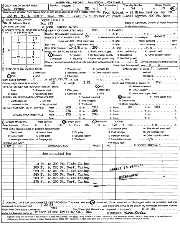
Specific Water Well Detail |
|
|
| Location Info | |||
| Owner: Lasalle, Roger | Status: Constructed | ||
| Location: T24S, R33W, Sec. 9, NE | County: Finney | ||
| Directions: 2.5 mi E on HWY 50, 466' S, 858' W, 194' S to NE corner of tract 2, 400' W | |||
| Latitude: 37.9855433 | Longitude: -100.9427222 | Datum NAD 27 | |
| Latitude: 37.985567 | Longitude: -100.9431645 | Datum NAD 83 | |
| Longitude and latitude calculated by Survey from township-range-section-quarter calls. Only good to within the quarter call accuracy. | |||
| View well on interactive map | |||
| General Info | ||
| Well Depth: 295 ft. | Elevation: ft. | |
| Static Water Level: 50 ft. | Est. Yield: gpm. | |
| Comp. Date: 30-Apr-1993 | Well Use: Domestic | |
| DWR Applic. #: | Other ID: | |
| Driller Info | ||
| Driller: Raymond A. Nicholson Drilling | License #: 206 | |
| Scanned Form | View scan |
|
Chemical Sample Submitted?: No
Water Well disinfected?: | ||
| Ground water encountered: 0 ft. , 0 ft. , 0 ft. | ||
| Pump test data: Well water was 0 ft after 0 hours pumping 0 gpm | ||
| Casing Info | ||
| Casing Type: PVC
Casing Joints: |
Diam: 5 in. to 0 ft
Diam: 0 in. to 0 ft Diam: 0 in. to 0 ft | |
| Casing height above land surface: in
Casing Weight: lbs/ft Wall thickness or gauge no.: | ||
| Screen and Perforation Info | ||
| Screen Type: PVC | Screen Openings: Saw cut | |
| Screen-perforated intervals | From: 200 ft to 220 ft
From: 240 ft to 260 ft From: 275 ft to 295 ft | |
| Gravel pack intervals | From: ft to ft | |
| Grout Info | ||
| Grout used: Cement grout, Bentonite | From: 5 to 35 ft
From: 35 to 175 ft From: 0 to 0 ft | |
| Source of Possible Contamination | ||
| Source: OTHER | ||
| Direction from well: | Distance: 0 ft | |
| Lithologic Log
(log data not edited or checked by the KGS.) | ||
| From: 0 ft. to 3 ft. | Type: CLAY | |
| From: 3 ft. to 6 ft. | Type: FINE SAND | |
| From: 6 ft. to 39 ft. | Type: SAND & GRAVEL | |
| From: 39 ft. to 56 ft. | Type: SANDY CLAY | |
| From: 56 ft. to 87 ft. | Type: SAND & GRAVEL | |
| From: 87 ft. to 136 ft. | Type: SANDY CLAY | |
| From: 136 ft. to 152 ft. | Type: ROCK & CLAY | |
| From: 152 ft. to 167 ft. | Type: SAND & GRAVEL | |
| From: 167 ft. to 173 ft. | Type: SANDY CLAY | |
| From: 173 ft. to 194 ft. | Type: SAND & GRAVEL | |
| From: 194 ft. to 211 ft. | Type: SANDY CLAY | |
| From: 211 ft. to 223 ft. | Type: SAND & GRAVEL | |
| From: 223 ft. to 243 ft. | Type: SANDY CLAY | |
| From: 243 ft. to 254 ft. | Type: SAND & GRAVEL | |
| From: 254 ft. to 260 ft. | Type: SANDY CLAY | |
| From: 260 ft. to 278 ft. | Type: CLAY | |
| From: 278 ft. to 290 ft. | Type: CLAY & GRAVEL | |
| From: 290 ft. to 313 ft. | Type: SANDY CLAY | |
| From: 313 ft. to 316 ft. | Type: ROCK & CLAY | |
| From: 316 ft. to 320 ft. | Type: CLAY | |