|
|
|
Specific Water Well Detail |
|
|
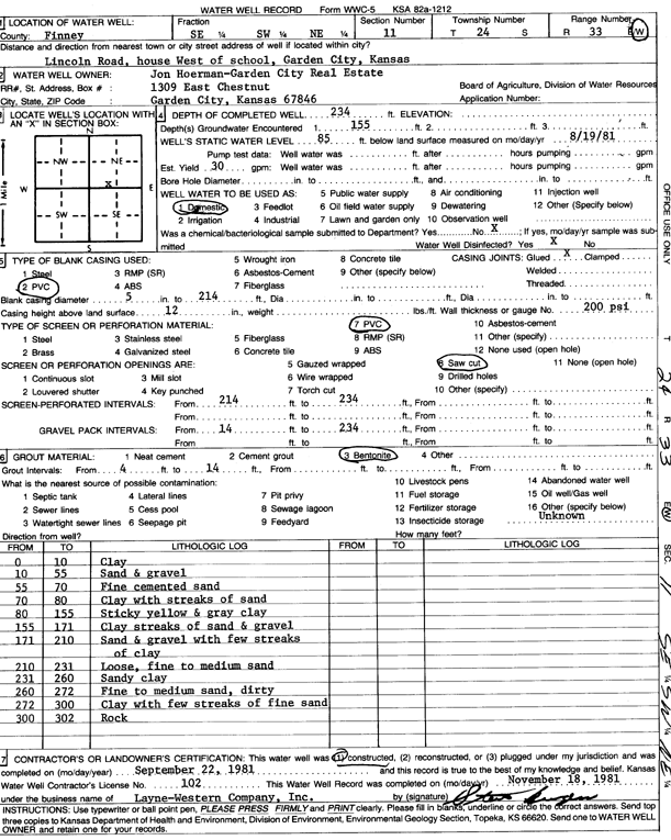
| Location Info | |||
| Owner: Hoerman, Jon | Status: Constructed | ||
| Location: T24S, R33W, Sec. 11, SE SW NE | County: Finney | ||
| Directions: Lincoln Rd, house W of School | |||
| Latitude: 37.9831214 | Longitude: -100.9070526 | Datum NAD 27 | |
| Latitude: 37.9831448 | Longitude: -100.9074936 | Datum NAD 83 | |
| Longitude and latitude calculated by Survey from township-range-section-quarter calls. Only good to within the quarter call accuracy. | |||
| View well on interactive map | |||
| General Info | ||
| Well Depth: 234 ft. | Elevation: ft. | |
| Static Water Level: 85 ft. | Est. Yield: 30 gpm. | |
| Comp. Date: 22-Sep-1981 | Well Use: Domestic | |
| DWR Applic. #: | Other ID: | |
| Driller Info | ||
| Driller: Layne-Christensen Co. | License #: 102 | |
| Scanned Form | View scan |
|
Chemical Sample Submitted?: No
Water Well disinfected?: | ||
| Ground water encountered: 0 ft. , 0 ft. , 0 ft. | ||
| Pump test data: Well water was 0 ft after 0 hours pumping 0 gpm | ||
| Casing Info | ||
| Casing Type:
Casing Joints: |
Diam: 0 in. to 0 ft
Diam: 0 in. to 0 ft Diam: 0 in. to 0 ft | |
| Casing height above land surface: in
Casing Weight: lbs/ft Wall thickness or gauge no.: | ||
| Screen and Perforation Info | ||
| Screen Type: | Screen Openings: | |
| Screen-perforated intervals | From: 214 ft to 234 ft
From: 0 ft to 0 ft From: 0 ft to 0 ft | |
| Gravel pack intervals | From: ft to ft | |
| Grout Info | ||
| Grout used: | From: 0 to 0 ft
From: 0 to 0 ft From: 0 to 0 ft | |
| Source of Possible Contamination | ||
| Source: | ||
| Direction from well: | Distance: 0 ft | |
| Lithologic Log
(Log data entered by KGS.) | ||
| From: 0 ft. to 10 ft. | clay | |
| From: 10 ft. to 55 ft. | sand and gravel | |
| From: 55 ft. to 70 ft. | fine cemented sand | |
| From: 70 ft. to 80 ft. | clay with streaks of sand | |
| From: 80 ft. to 155 ft. | sticky yellow and gray clay | |
| From: 155 ft. to 171 ft. | clay streaks of sand and gravel | |
| From: 171 ft. to 210 ft. | sand and gravel with few streaks of clay | |
| From: 210 ft. to 231 ft. | loose, fine to medium sand | |
| From: 231 ft. to 260 ft. | sandy clay | |
| From: 260 ft. to 272 ft. | fine to medium sand, dirty | |
| From: 272 ft. to 300 ft. | clay with few streaks of fine sand | |
| From: 300 ft. to 302 ft. | rock | |