|
|
|
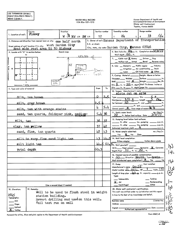
Specific Water Well Detail |
|
|
| Location Info | |||
| Owner: Kansas Dept. of Transportation | Status: Constructed | ||
| Location: T24S, R33W, Sec. 12, W2 NW SW | County: Finney | ||
| Directions: from Garden City, 0.5 mi NW, road side rest area US 50 HWY | |||
| Latitude: 37.9804051 | Longitude: -100.9001689 | Datum NAD 27 | |
| Latitude: 37.9804283 | Longitude: -100.9006096 | Datum NAD 83 | |
| Longitude and latitude calculated by Survey from township-range-section-quarter calls. Only good to within the quarter call accuracy. | |||
| View well on interactive map | |||
| General Info | ||
| Well Depth: 60 ft. | Elevation: ft. | |
| Static Water Level: 22 ft. | Est. Yield: 4 gpm. | |
| Comp. Date: 09-Mar-1977 | Well Use: Domestic | |
| DWR Applic. #: | Other ID: | |
| Driller Info | ||
| Driller: KDOT | License #: | |
| Scanned Form | View scan |
|
Chemical Sample Submitted?: No
Water Well disinfected?: | ||
| Ground water encountered: 0 ft. , 0 ft. , 0 ft. | ||
| Pump test data: Well water was 0 ft after 0 hours pumping 0 gpm | ||
| Casing Info | ||
| Casing Type:
Casing Joints: |
Diam: 0 in. to 0 ft
Diam: 0 in. to 0 ft Diam: 0 in. to 0 ft | |
| Casing height above land surface: in
Casing Weight: lbs/ft Wall thickness or gauge no.: | ||
| Screen and Perforation Info | ||
| Screen Type: | Screen Openings: | |
| Screen-perforated intervals | From: 45 ft to 50 ft
From: 0 ft to 0 ft From: 0 ft to 0 ft | |
| Gravel pack intervals | From: ft to ft | |
| Grout Info | ||
| Grout used: | From: 0 to 0 ft
From: 0 to 0 ft From: 0 to 0 ft | |
| Source of Possible Contamination | ||
| Source: | ||
| Direction from well: | Distance: 0 ft | |
| Lithologic Log
(Log data entered by KGS.) | ||
| From: 0 ft. to 2.5 ft. | silt, tan brown | |
| From: 2.5 ft. to 4 ft. | silt, gray brown | |
| From: 4 ft. to 5.4 ft. | silt, tan with orange stains | |
| From: 5.4 ft. to 36 ft. | sand, tan quartz, feldspar pink, medium-coarse | |
| From: 36 ft. to 37 ft. | silt, tan | |
| From: 37 ft. to 42 ft. | clay, tan yellow | |
| From: 42 ft. to 43 ft. | sand, fine, tan quartz | |
| From: 43 ft. to 44.5 ft. | silt to very fine sand light tan | |
| From: 44.5 ft. to 60.3 ft. | silt light tan | |