|
|
|
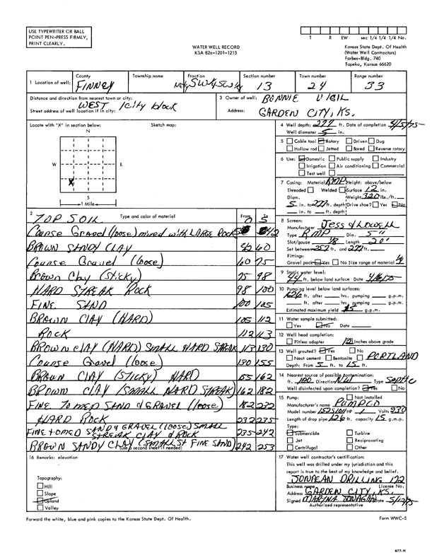
Specific Water Well Detail |
|
|
| Location Info | |||
| Owner: Vigil, Bonnie | Status: Constructed | ||
| Location: T24S, R33W, Sec. 13, NE SW SW | County: Finney | ||
| Directions: W 1 city block | |||
| Latitude: 37.9628412 | Longitude: -100.8975806 | Datum NAD 27 | |
| Latitude: 37.9628645 | Longitude: -100.8980213 | Datum NAD 83 | |
| Longitude and latitude calculated by Survey from township-range-section-quarter calls. Only good to within the quarter call accuracy. | |||
| View well on interactive map | |||
| General Info | ||
| Well Depth: 277 ft. | Elevation: ft. | |
| Static Water Level: 44 ft. | Est. Yield: 15 gpm. | |
| Comp. Date: 05-Apr-1975 | Well Use: Domestic | |
| DWR Applic. #: | Other ID: | |
| Driller Info | ||
| Driller: Jonagan Water Well Service LLC | License #: 172 | |
| Scanned Form | View scan |
|
Chemical Sample Submitted?: No
Water Well disinfected?: | ||
| Ground water encountered: 0 ft. , 0 ft. , 0 ft. | ||
| Pump test data: Well water was 0 ft after 0 hours pumping 0 gpm | ||
| Casing Info | ||
| Casing Type:
Casing Joints: |
Diam: 0 in. to 0 ft
Diam: 0 in. to 0 ft Diam: 0 in. to 0 ft | |
| Casing height above land surface: in
Casing Weight: lbs/ft Wall thickness or gauge no.: | ||
| Screen and Perforation Info | ||
| Screen Type: | Screen Openings: | |
| Screen-perforated intervals | From: 257 ft to 277 ft
From: 0 ft to 0 ft From: 0 ft to 0 ft | |
| Gravel pack intervals | From: ft to ft | |
| Grout Info | ||
| Grout used: | From: 0 to 0 ft
From: 0 to 0 ft From: 0 to 0 ft | |
| Source of Possible Contamination | ||
| Source: | ||
| Direction from well: | Distance: 0 ft | |
| Lithologic Log
(Log data entered by KGS.) | ||
| From: 0 ft. to 5 ft. | topsoil | |
| From: 5 ft. to 42 ft. | coarse gravel (loose) mixed with large rock | |
| From: 42 ft. to 60 ft. | brown sandy clay | |
| From: 60 ft. to 75 ft. | coarse gravel (loose) | |
| From: 75 ft. to 98 ft. | brown clay (sticky) | |
| From: 98 ft. to 100 ft. | hard streak rock | |
| From: 100 ft. to 105 ft. | fine sand | |
| From: 105 ft. to 112 ft. | brown clay (hard) | |
| From: 112 ft. to 113 ft. | rock | |
| From: 113 ft. to 130 ft. | brown clay (hard) small hard streak | |
| From: 130 ft. to 155 ft. | coarse gravel (loose) | |
| From: 155 ft. to 162 ft. | brown clay (sticky) hard | |
| From: 162 ft. to 182 ft. | brown clay (small hard streak) | |
| From: 182 ft. to 232 ft. | fine to medium sand and gravel (loose) | |
| From: 232 ft. to 235 ft. | hard rock | |
| From: 235 ft. to 242 ft. | fine to medium sand and gravel (loose) small streak clay and rock | |
| From: 242 ft. to 253 ft. | brown sandy clay (small st fine sand) | |