|
|
|
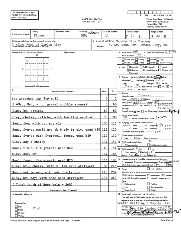
Specific Water Well Detail |
|
|
| Location Info | |||
| Owner: Garden City Co. | Status: Constructed | ||
| Location: T24S, R33W, Sec. 14, NW SW NW | County: Finney | ||
| Directions: from Garden City, 2 mi W | |||
| Latitude: 37.9704901 | Longitude: -100.9185116 | Datum NAD 27 | |
| Latitude: 37.9705136 | Longitude: -100.918953 | Datum NAD 83 | |
| Longitude and latitude calculated by Survey from township-range-section-quarter calls. Only good to within the quarter call accuracy. | |||
| View well on interactive map | |||
| General Info | ||
| Well Depth: 195 ft. | Elevation: ft. | |
| Static Water Level: 58 ft. | Est. Yield: gpm. | |
| Comp. Date: 08-Jan-1975 | Well Use: Irrigation | |
| DWR Applic. #: | Other ID: | |
| Driller Info | ||
| Driller: Hydro Res. Mid Continent #145 | License #: 145 | |
| Scanned Form | View scan |
|
Chemical Sample Submitted?: No
Water Well disinfected?: | ||
| Ground water encountered: 0 ft. , 0 ft. , 0 ft. | ||
| Pump test data: Well water was 0 ft after 0 hours pumping 0 gpm | ||
| Casing Info | ||
| Casing Type:
Casing Joints: |
Diam: 0 in. to 0 ft
Diam: 0 in. to 0 ft Diam: 0 in. to 0 ft | |
| Casing height above land surface: in
Casing Weight: lbs/ft Wall thickness or gauge no.: | ||
| Screen and Perforation Info | ||
| Screen Type: | Screen Openings: | |
| Screen-perforated intervals | From: 125 ft to 135 ft
From: 145 ft to 155 ft From: 175 ft to 185 ft | |
| Gravel pack intervals | From: ft to ft | |
| Grout Info | ||
| Grout used: | From: 0 to 0 ft
From: 0 to 0 ft From: 0 to 0 ft | |
| Source of Possible Contamination | ||
| Source: | ||
| Direction from well: | Distance: 0 ft | |
| Lithologic Log
(Log data entered by KGS.) | ||
| From: 0 ft. to 5 ft. | top soil | |
| From: 5 ft. to 60 ft. | sand and gravel, medium, very coarse gravel (cobble stones) | |
| From: 60 ft. to 80 ft. | clay, brown, sticky | |
| From: 80 ft. to 100 ft. | clay, chalky, caliche, with few fine sand streaks | |
| From: 100 ft. to 115 ft. | fine-medium sand with brown sandy clay | |
| From: 115 ft. to 120 ft. | fine-medium-coarse sand, small gypsum rock, and sandy brown clay | |
| From: 120 ft. to 137 ft. | fine-medium-coarse sand with fine-gravel, loose | |
| From: 137 ft. to 140 ft. | clay, sandy and chalky | |
| From: 140 ft. to 154 ft. | fine-medium-coarse sand and fine-medium gravel | |
| From: 154 ft. to 165 ft. | sandy clay, brown | |
| From: 165 ft. to 188 ft. | fine-medium-coarse sand and fine-medium gravel | |
| From: 188 ft. to 215 ft. | clay, brown, chalky, with very few sand stringers | |
| From: 215 ft. to 237 ft. | very fine to medium-coarse sand with sandy chalky clay | |
| From: 237 ft. to 260 ft. | sandy clay, brown, with some sand stringers | |